Fun swells from Friday, best Saturday

Eastern Tasmania Surf Forecast by Craig Brokensha (issued Monday 17th July)
Best Days: Later Wednesday, Friday, Saturday
Recap
Flat clean surf Saturday, while Sunday and today some tiny E'ly windswell has provided dribbly 1ft waves at open beaches.
This week and weekend (Jul 18 - 23)
We'll probably see some tiny weak levels of N/NE windswell across the coast tomorrow morning, but of greater importance is a mid-latitude moving in from the west during the middle of the week.
As touched on last week, we'll see this low push across us Wednesday with an initial fetch of strong S'ly winds projected up along our coast.
 This should generate a burst of S'ly windswell to 3-4ft across south magnets through the day. Winds will be poor during the morning with a fresh and gusty S/SW'ly, but a secondary polar front approaching the state from the south-west will swing winds around to the W/SW later in the day.
The swell will fade overnight leaving tiny waves Thursday morning, but a developing Tasman Low will project a fetch of strong SE winds towards us through the day, kicking up some new S/SE windswell later in the day to the 3ft range.
Friday looks much better as the swell tends more SE under offshore W/NW winds. Open beaches should see 3ft waves, persisting most of the day.
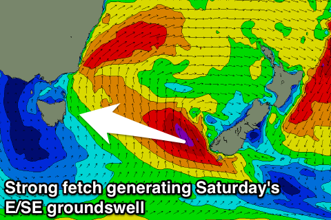
Now, as the Tasman Low drifts east towards New Zealand a significant fetch of severe-gale to storm-force SE winds are forecast to be generated on the edge of our swell window, with some good E/SE groundswell spreading out radially towards us.
This swell is expected to arrive Saturday and offer 3-4ft waves at open beaches with offshore NW winds, fading quickly into Sunday from 2ft max.
Longer term we may see some new S'ly swell mid-next week, but more on this Wednesday.