Mix of S'ly and SE swell for the weekend

Eastern Tasmania Surf Forecast by Craig Brokensha (issued Friday 30th June)
Best Days: Saturday south magnets, Sunday, Monday northern corners
Recap
The S'ly swell hung in yesterday with fun waves across exposed coast with an offshore breeze.
Today a strong cold front pushing up past the coast has brought with it an increase in mid-period S'ly swell but with average winds. We should see winds back off and tend more offshore on dark, so check south magnets for a late one.
This weekend and next week (Jul 1 - 7)
The strong cold-outbreak responsible for today's S'ly swell is drifting slowly north-east, with the local fetch of S'ly winds through our southern swell window expected to move away early tomorrow.
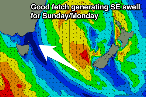
We'll see a good fetch of broad and strong S/SE winds forming just west of the South Island tomorrow, weakening slowly Sunday and this should produce a reinforcing SE swell for Sunday and Monday.
 Tomorrow easing levels of S/SE swell are expected from 2ft+ across south facing beaches with an offshore W/NW tending N'ly breeze.
The SE swell should build through Sunday, reaching 2-3ft into the afternoon, easing back from a slightly smaller size Monday morning.
A NW tending N/NW breeze will create clean conditions Sunday, while fresher N/NE tending N/NW winds are due Monday as a small trough deepens and then moves offshore.
This will add a N/NE windswell into the mix, coming in around 2ft at north facing breaks Monday, fading Tuesday with offshore W/NW winds.
Longer term the outlook is still a little undecided but check back Monday for the latest update. Have a great weekend!