Fun S'ly swell Wednesday, kicking again Friday, smaller into the weekend
Eastern Tasmania Surf Forecast by Craig Brokensha (issued Monday 26th June)
Best Days:
Recap
A fun mix of easing E/NE and new S'ly groundswell Saturday coming in at 3ft across the coast before fading back into Sunday to 1-2ft at south magnets.
Today another small S'ly swell has come in across the coast, linked to an overnight change, maxing at 2-3ft across south swell magnets with offshore winds.
This week and weekend (June 27 – Jul 2)
Today's S'ly swell is linked to a broad but not overly strong cold front pushing up and across the state yesterday, and we've got a secondary pulse of reinforcing swell due tomorrow, produced by a trailing fetch of strong W/SW winds just within our swell window last night and early this morning.
South magnets should see 3ft sets all day with offshore winds, becoming small to tiny Wednesday as W/NW breezes persist.
 We then look to the end of the week when a strong cold-outbreak is expected across the state bringing cold weather and snow.
This cold-outbreak will send a fetch of strong S/SW winds up past our coast Thursday afternoon through Friday, generating a moderate sized mid-period S'ly swell for Friday, easing out of the S/SE Saturday.
South facing beaches will be a bumpy and windy 3-4ft Saturday, cleaner and easing from 3ft+ or so Saturday.
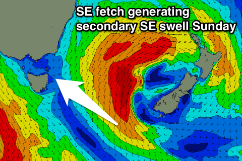
We're likely to see a small pulse of SE swell from the system as it forms into a Tasman Low on the weekend, coming in at 3ft Sunday but with N/NW winds. More on this Wednesday.

