Small swells for the period
Eastern Tasmania Surf Forecast by Craig Brokensha (issued Friday 23rd June)
Best Days: Swell magnets tomorrow, Monday afternoon and Tuesday morning
Recap
Fun but inconsistent amounts of E/NE swell yesterday to 2-3ft, with a further increase expected through the day.
This morning should of still been an easy 3ft, persisting all day, but surf reports from this morning were much smaller. The same swell impacted the mainland offering inconsistent 3-4ft+ waves today, so the report may have been lodged in between sets.
This weekend and next week (June 24 - 30)
The E/NE swell seen through today should tail off through tomorrow, dropping from an inconsistent 2ft at magnets through the morning, tiny into the afternoon.
The S'ly groundswell for tomorrow is now looking a little flukey with the very strong polar frontal progression generating it staying a touch further north and west, resulting in a bit more west than ideal in the swell.
The polar front that first formed mid-week was more in our swell window and we should see this system providing inconsistent 2ft sets at south magnets through the morning, easing through the day, tiny into Sunday.
 Conditions look great tomorrow with a moderate to fresh offshore W'ly tending W/NW breeze, while Sunday will see NW tending W'ly winds.
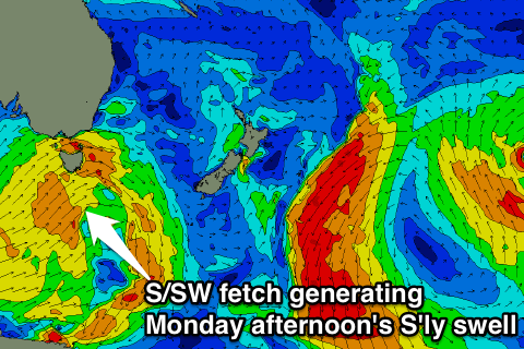
An overnight change Sunday will be linked to a weakening frontal system pushing up and past us. This front will produce a fetch of strong S/SW winds through our southern swell window, producing a new S'ly swell for Monday that should build to 2-3ft at south facing beaches through the day.
Conditions look favourable with a W/SW breeze most of the day, while Tuesday will be cleanest with a W/NW offshore as the swell eases from the 2ft range.
Longer term there's some possible developments late next week/weekend as a strong cold-outbreak merges with a deepening inland surface trough drifting south-east across the country. More on this Monday. Have a great weekend!

