Great easterly swell to end the week

Eastern Tasmania Surf Forecast by Craig Brokensha (issued Wednesday 12th April)
Best Days: Thursday morning, Friday, Saturday morning
Recap
After the swell kicked through Monday, yesterday saw small and bumpy surf easing from 2ft across the coast.
This morning the surf became tiny with nowhere to recommend for a paddle.
This week and weekend (Apr 13 - 16)
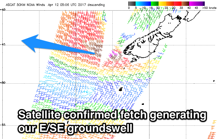
Our attention swings to the Tasman Low that's sitting east of us, generating a great fetch of E/SE gales through our swell window.
Satellite observations have picked up the fetch and it's looking great with core wind speeds in excess of 40kts.
 We should see a strong E/SE groundswell spreading out and into us tomorrow, building strongly into the afternoon.
Open beaches should see easy 3ft sets during the morning, kicking strongly to 3-5ft into the mid-afternoon, peaking overnight/early Friday to 4-5ft.
A slow easing trend should be seen Friday afternoon due to the low maintaining a good fetch of E/SE winds in our swell window through tomorrow before breaking down Friday morning.
Saturday morning should still see 2-3ft sets, much smaller into the afternoon.
Light variable winds are expected tomorrow morning ahead of N/NE sea breezes, while Friday looks excellent with a gusty W/SW tending S/SW breeze. Saturday morning will be clean again under light offshores, with NE sea breezes into the afternoon.
The secondary SE swell on the cards for Sunday/Monday isn't as good anymore with the weak SE fetch that was forecast to project towards us, not on the cards any more.
There's also nothing significant for next week at all as the westerly storm track kicks into gear, therefore make the most of the coming E/SE groundswell.