Fun weekend, small to tiny next week
Eastern Tasmania Surf Forecast by Craig Brokensha (issued Friday 24th March)
Best Days: Northern corners Saturday, Sunday morning
Recap
Good levels of E'ly swell the last two days, with 3-4ft sets yesterday and this morning. Southern corners were cleanest yesterday morning while a straighter offshore was seen this morning.
This weekend and next week (Mar 25 - 31)
The slow moving Tasman Low linked to our current E'ly swell is still sitting between us and New Zealand, generating a fetch of strong SE winds on the periphery of our eastern swell window.
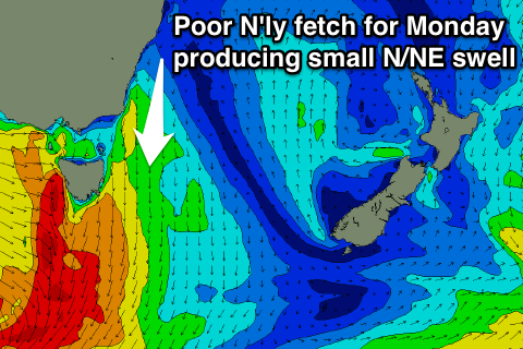
The low will finally move east and out of our swell window tomorrow, with a weak E/NE fetch just within our swell window off New Zealand's West Coast not expected to generate too much reinforcing E/NE swell early next week.
So what we can expect is easing E'ly swell slowly from 3ft tomorrow morning, if not for the odd bigger one at dawn, smaller from 2ft max Sunday. N/NW-N winds will favour northern corners so stick to them tomorrow, with N/NE breezes into the afternoon.
Sunday then looks clean at all locations with offshore W'ly winds ahead of E'ly sea breezes.
 A N/NE windswell showing for Monday will be very fleeting and probably won't generate much size above 1-2ft into the middle of the day/afternoon, just as an offshore change moves through, tiny Tuesday.
Into Thursday a similar sized N/NE windswell is on the cards from a weak fetch of NE winds developing down the southern NSW coast, but again size looks to be limited to 1-2ft max.
Other than this, the westerly storm track will set in motion a series of vigorous cold fronts through the Southern Ocean but all the activity will be too west to get into our region. Therefore make the most of the weekend's waves. Have a great weekend!

