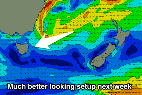
Fun E/NE swell tomorrow, easing with better developments next week
Eastern Tasmania Surf Forecast by Craig Brokensha (issued Wednesday 1st March)
Best Days: Thursday morning, south magnets Saturday, Sunday morning, middle of next week onwards
Recap
Small amounts of E/NE swell across the coast but to no major size or any major quality.
This week and weekend (Mar 2 - 5)
Currently the weak but persist fetch of E/NE winds through the Tasman Sea and our swell window is weakening.
With this we'll see the swell ease off from tomorrow afternoon, but before this, the strongest period pulse of ENE swell is due tomorrow morning.
This should provide 2-3ft sets at open beaches most of the day, easing back from 2ft Friday morning.
A light offshore wind should create clean conditions before a shallow E/SE change moves through.
The SE swell from a S/SE change on Friday now looks minimal, with better developments into next week.
 The S'ly groundswell for later Friday and Saturday morning is looking good, with the low that's forecast to produce it currently deepening south-west of the state.
The low will move into our swell window tomorrow, with a fetch of gale to severe-gale W/SW winds being generated in our southern swell window.
A late increase in size is due Friday, probably to 2-3ft at south magnets, easing from a similar size Saturday morning, small into the afternoon.
Onshore winds Friday from the S/SE-SE will tend light offshore Saturday morning before sea breezes kick in.
Now, looking into the longer term forecast, and as touched last update a much broader and stronger Tasman Low is forecast to form off the southern NSW coast next week, with a strong high moving in from the west, allowing a good and broad SE tending E'ly fetch to develop through our eastern swell window.
This will generate some good and long-lived E'ly swell from the middle of next week through until the following weekend with favourable winds. We'll nail down more of the specifics on Friday though.

