S'ly swell about the best of it
Eastern Tasmania Surf Forecast by Craig Brokensha (issued Monday 13th February)
Best Days: Tuesday afternoon and Wednesday morning at south magnets, later Friday and Saturday morning
Recap
A fun morning of surf Saturday, smaller through Sunday.
Today some new S'ly swell should be building across the coast, but the better pulse looks to fill in tomorrow.
This week (Feb 14 - 19)
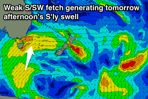
Currently a cold front is pushing up past us, but the fetch in our swell window isn't too significant and SW in direction.
 A better aligned fetch of strong S/SW winds from the polar shelf should produce a better S'ly pulse tomorrow afternoon, building to 2ft to maybe 3ft at south magnets. In the morning it will likely be smaller with the more west in the swell.
This swell will fade through Wednesday though from 1-2ft.
Winds tomorrow should be offshore from the W/SW through the morning, with NE sea breezes favouring protected northern corners. Wednesday is then looking clean all day at south magnets with a N/NW offshore.
No N'ly windswell is expected off this fetch, with it being too north in nature to be ideal.
Through the rest of the week there's nothing major on the cards, with a small NE windswell Saturday being quite flukey with the fetch off the NSW coast not extending to us. A better S/SE groundswell is due from a polar fetch of severe-gale to storm-force S/SE winds on the polar shelf, and this should provide 2ft sets at magnets.
Beyond this we aim our eyes to our tropical swell window with the possibility of a sustained trade-flow generating some E/NE-NE swell for later next week. But more on this Wednesday.

