Fun NE and E/SE swells to end the week

Eastern Tasmania Surf Forecast by Craig Brokensha (issued Monday 26th December)
Sign up to Swellnet’s newsletter and receive the Eastern Tasmania Forecaster Notes and latest news sent directly to your inbox. Upon signup you'll also enter the draw to win a surf trip to P-Pass for you and a mate. It doesn’t get much easier so click HERE to sign up now.
Best Days: Thursday southern corners north of Freycinet, Friday open beaches, Saturday morning open beaches
Recap
Onshore winds and a small leftover north-east swell yesterday morning from Monday, while today cleaner 2ft waves were seen.
This week and weekend (Dec 29 – Jan 1)
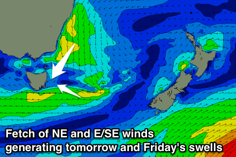 Our better increase in NE swell due tomorrow across the coast is still on track, with a broad and strong fetch of NE winds due to develop down the NSW coast and across the exit to Bass Strait this afternoon and evening before retracting early tomorrow morning.
A good pulse of NE swell is due across north facing beaches, coming in around an easy 3ft tomorrow morning, if not a little bigger on the bombs.
A drop in size is due from late morning and conditions are looking good in southern corners with a SW tending SE breeze (E'ly around Eagle Hawk Neck and the Freycinet region).
The E'ly wind across the southern half of the coast will be linked to a fetch of strong E/SE winds forming through our swell window tomorrow, and should produce a fun E/SE swell later in the day and for Friday morning to 2-3ft across open beaches.
Conditions will be good as well with a N/NW tending NW breeze.
Into the weekend, the E/SE and NE swells look to be all but gone with fading 1-2ft sets and offshore winds, tiny Sunday.
Next week onwards (Jan 2 onwards)
Another similar trough to that seen tomorrow is expected to move through our swell window over the weekend and early next week, producing another small SE swell for nexy week, but more on this Friday.