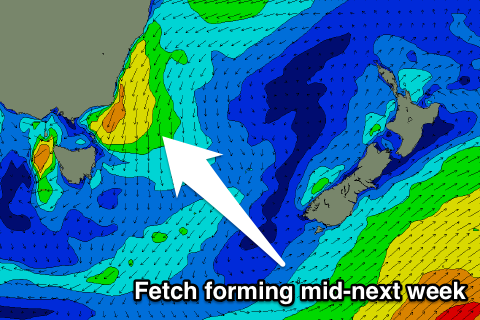
Plenty of swell from the north-east for the period
Eastern Tasmania Surf Forecast by Craig Brokensha (issued Friday 23rd December)
It's only two sleeps to go until Christmas Day. If you're looking for a surfer's perfect present and don't want to endure the shopping centre masses you can pick up a Swellnet Pro Subscription gift pack. Treat someone else or treat yourself and get a free Swellnet leggy and surf tested sunscreen: https://www.swellnet.com/pro/gift
Best Days: North facing beaches Monday afternoon, Thursday
Recap
Tiny waves yesterday but today a very inconsistent NE trade-swell should have been sen across magnets.
This weekend and next week (Dec 24 - 30)
Our swell window will be dominated by swell out of the north-east for the coming period.
Inconsistent levels of NE trade-swell should persist tomorrow and Sunday to 1-2ft at swell magnets, but some more consistent NE windswell will start to develop tomorrow afternoon, holding Sunday before becoming bigger into next week.
 This will be due to a persistent fetch of NE winds off our coast from tomorrow afternoon, strengthening overnight Sunday, retreating through Monday as a S'ly change moves through.
This change will be temporary though, with E/NE winds due to establish again through Tuesday and Wednesday, feeding into a low drifting south of South Australia.
What we should see is 3ft of NE windswell Monday, possibly a little stronger through the day with N/NW winds ahead of a S'ly change.
Tuesday will then be small and onshore with a mix of easing NE windswell, S'ly windswell from the change, and new increase in E'ly windswell from the strengthening E'ly fetch.
More size and power should be seen Wednesday to 3-4ft but with onshore winds.
The biggest increase in NE windswell is likely Thursday as the fetch off our coast strengthens ahead of a NW change. North facing beaches are due to come in around 3-4ft+, cleaning up through the day.
We'll have another look at this Monday though. Have a Merry Christmas and great weekend!

