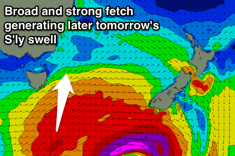
S'ly swell for magnets later tomorrow and Friday morning
Eastern Tasmania Surf Forecast by Craig Brokensha (issued Wednesday 14th December)
Sign up to Swellnet’s newsletter and receive the Eastern Tasmania Forecaster Notes and latest news sent directly to your inbox. Upon signup you'll also enter the draw to win a surf trip to P-Pass for you and a mate. It doesn’t get much easier so click HERE to sign up now.
Best Days: Later Thursday south swell magnets and Friday morning, Saturday morning north facing beaches, Tuesday when the change hits
Recap
Tiny waves the last few days but we should see some small S'ly swell later this week.
This week and weekend (Dec 15 - 18)
A really strong embedded low moved past us this morning with a fetch of severe-gale to storm-force W'ly winds generated directly south-east of us.
This fetch and low was too west in nature to generate any swell for tomorrow though.
 Instead a better trailing fetch of W/SW gales stalling south-southeast of us this evening and tomorrow morning should produce a small pulse of S'ly groundswell for later tomorrow and early Friday.
2-3ft sets are due across south swell magnets, fading through Friday with W'ly tending N/NE winds tomorrow and N/NW tending N/NE winds Friday.
These N/NE winds will freshen off our coast ahead of a change Saturday but no major north-east swell is due, with easing 1-2ft sets max.
A southerly change due Saturday afternoon doesn't look to have much strength to it, with 1-2ft waves max due at south swell magnets along with SW winds.
Into early next week though we may see a strong and elongated fetch of N/NE winds developing down the southern NSW coast and our coast.
A moderate sized N/NE swell is expected to develop, cleaning up through Tuesday with a change, but we'll have another look at this Friday.

