Good NE swell event, cleanest from Saturday

Eastern Tasmania Surf Forecast by Craig Brokensha (issued Wednesday 7th September)
Best Days: Saturday, Sunday
Recap
Tiny waves yesterday with a slight kick in S'ly swell today. Clean and OK early before onshores kicked in.
This week and weekend (Sep 8 - 11)
Building levels of N/NE windswell are on the cards for the coming days, with the swell actually hanging in nicely as winds improve from the weekend.
This will be linked to a strong high pressure ridge in the Tasman Sea being squeezed by a strong frontal system moving in from the Bight.
The front will take a little time to get here allowing the N/NE winds to persist over the coming days.
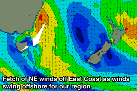 The winds will start to develop this afternoon, becoming broad and strong overnight, producing 2-3ft surf for tomorrow out of the NE.
The fetch will weaken slightly into tomorrow afternoon/evening, resulting in the swell steadying. A re-consolidation during Thursday evening should see some stronger NE swell growing out in period and reaching 3-4ft through the day.
Winds through these days will be less than ideal for locations picking up the size though with a fresh N'ly tending N/NW breeze tomorrow, N/NW most of Friday. We may see a late SW change but we'll review this Friday.
Into the weekend the fetch will start pushing away from our immediate coast, but extend all the way up the East Coast, helping to keep less consistent but good 3ft+ sets hitting north-east facing beaches through Saturday, easing from 2ft+ Sunday.
Conditions will be great Saturday with a W/SW change, and then W/NW winds Sunday.
Into Monday there's no major swell due to be left across the coast, but some fun S'ly groundswell may be seen through the middle of the week. More on this Friday.