Stick to the open beaches for hints of small surf
Eastern Tasmania Surf Forecast by Guy Dixon (issued Monday 25th April)
Best Days: No great days.
Recap:
A southerly groundswell increased to around 2ft+ at exposed magnets on Saturday, before easing from a similar size on Sunday. Conditions remained clean until mid-morning each day preceding a northeasterly seabreeze.
Today, the surf has eased off the back of the weekend swell, with offshore breezes persisting until lunchtime.
This week (Tuesday 26th - Friday 29th) and this weekend (Saturday 30th - Sunday 1st):
We are looking at a pretty quiet week ahead, with today’s easing southerly swell continuing to fade into Tuesday with options dropping back to a weak 1ft.
Hints of east/northeasterly energy may be evident across open beaches on Tuesday and Wednesday as a result of an elongated southeasterly fetch which has been established with good alignment to northern NSW over the past few days.
Sideband energy off this fetch is due to filter down the coast, grading smaller further south and away from the swell source. By the time it reaches our open beaches, size is likely to be negligible with just over 1ft of swell keeping it from falling completely flat.
Conditions are likely to remain clean under a northwesterly airflow on Tuesday, tending north/northwesterly and freshening on Wednesday, possibly adding an element of bump to exposed stretches of coastline.
A blocking high looks to then set up over the Tasman sea, deflecting frontal paths in a poor southeastward direction through the southern swell window.
As a result, any southerly groundswell is virtually off the cards in the near future.
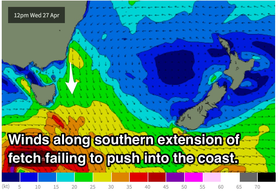
 However, a northerly fetch looks to increase throughout Wednesday under a tightening pressure gradient tightens as a an approaching front and trough are squeezed south of this stubborn ridge.
Despite spanning a decent area, this fetch never look to be overly intense, nor does it push into the coast before, so wave heights should only be modest. Open beaches should peak on Thursday morning in the 1-2ft range, fading rapily thereafter.
Conditions should remain generally clean for the majority of the day, with a shallow change moving through later in the afternoon.
A second very similar local northerly regime looks to develop leading into the weekend with northeast facing beaches building to just over 1ft on Friday, with slightly more distant fetches off the coast of NSW filling on Saturday providing peaks in the 1-2ft range.
Fresh north/northwesterly breeze may add an element of bump to exposed coasts.
More activity is on the cards later in the forecast with frontal activity moving locally, but the alignment is looking vary shaky. More detail on Wednesday.

