Clean conditions each day, solid E/NE groundswell peaking on Sunday
Eastern Tasmania Surf Forecast by Guy Dixon (issued Monday 22nd February)
Best Days: Each day from Wednesday, particularly Sunday morning.
Recap:
Fun options each morning of the weekend with around 2-3ft breaking across open beaches under northwesterly breezes. Conditions have remained fairly clean each day until around mid-late morning preceding a northeasterly seabreeze. From then on, conditions have become pretty lacklustre.
This week (Tuesday 23rd - Friday 26th):
We are expecting hints of the next pulse of east/northeasterly groundswell to begin filling in across the open beaches on Tuesday, with the size building to around 2ft+ by the afternoon.
The early morning session will offer the best chance of a clean wave, before breezes swing north/northeasterly and increase throughout the day.
Open beaches should continue seeing ebbs and pulses between 2-3ft through Wednesday and Thursday, largely generated by an intensification of Severe Tropical Cyclone Winston and the associated feeder ridge located to the south late last week.
Sets are likely to be inconsistent to start off with due to the long range nature of this swell, improving marginally into Wednesday.
Meanwhile, a northeasterly fetch also looks to develop off the coast of NSW throughout Tuesday and Wednesday, although the southern extent of this fetch only looks to have favourable alignment for a brief fleeting moment late on Tuesday, so the impacts should be fairly negligible.
Open beaches may see hints of background energy to around 1-2ft on Wednesday and Thursday, likely overshadowed by the longer range east/northeast swell.
The one handy aspect of this shorter range swell will be consistency. Although small, this northeasterly energy should help the impatient ones amongst us, giving us something to work with in between sets.
Wednesday and Thursday are looking fun virtually all day with northwesterly breeze looking to dominate for the best part of each day.
Winston is due to begin drifting southward from around Tuesday out from behind the swell shadow of New Caledonia which bodes well for the east coast of Tasmania. Things look to become interesting late in the week as long range energy continues to build.
Friday should see sets hold in the 3ft range across open beaches winds also cooperating. A westerly airflow should remain established over the region for the majority of the day.
This weekend (Saturday 27th - Sunday 28th):
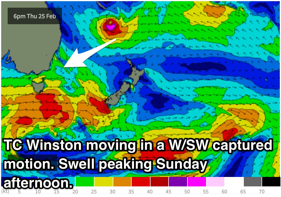
Throughout Wednesday and Thursday, models indicate Winston to move in a west/southwesterly direction towards the east coast coast of Australia, moving in a captured motion with fetches of 40-50kts.
 It’s not often that a system like this move in a captured motion with such alignment to the east coasts of Australia. In fact there is some very interesting commentary in the comments section of southeastern QLD/northern NSW forecast notes which discusses the track of TC Sose (Summer of 2000/01) which moved in a comparable motion, although not moving as close to the east coast as this occasion.
The latest model runs have the system stalling at around 160 degrees east, which is actually more favourable for the Tassie coast than pushing further west,
Open beaches have the potential to build to the 3-4ft range by Saturday afternoon, further to the 4-6ft range on Sunday afternoon. Swell magnets that are known to amplify these long period east/northeast groundswells will be bigger again at the swells peak.
Westerly winds are on the cards for both Saturday and Sunday, holding until around mid-afternoon before a light seabreeze becomes established. Even then, it should be pretty easy to find a workable set up.
It is worth mentioning that this swell is likely to be very powerful with solid wash through sets. Easterly swells of this magnitude are a rarity along these parts of the coast so it’ll be only for the experienced surfers.
Next week (Monday 29th onward):
Looking long term, the situation looks too good to be true. Call me a pessimist, but this swell surely cant give another round of swell can it? Looks like it may.
After undergoing extra-tropical transition, models suggest this system could stall over the central Tasman as a small ridge sets up to the south. A resultant easterly swell is on the cards for midway through next week, but this scenario has a pretty good chance of changing in the coming days.

