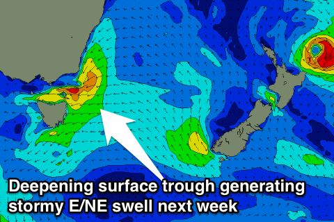
Inconsistent weekend, stormy mix of swells developing mid-week
Eastern Tasmania Surf Forecast by Guy Dixon (issued Friday 22nd January)
Best Days: Saturday and Sunday at southern ends of open beaches.
Recap:
Thursday offered tiny surf, nudging the 1ft range across open beaches, although offshore breezes kept conditions clean until early afternoon. Today, we saw an increase in size as the forerunners of TC Victor filled in. Inconsistent 2ft sets were breaking across open beaches under an offshore breeze until mid-morning.
This weekend (Saturday 23rd - Sunday 24th):
The most notable swell in the water in the coming days is likely to be very long range east/northeasterly groundswell, generated by Severe Tropical Cyclone Victor which has been lingering over the tropical South Pacific over the past few days.
This system is forecast to continue on its southward path, while weakening slightly on Saturday. As Saturday turns into Sunday, we look forward to seeing a re-intensification of this system as it undergoes extra-tropical transistion. Being closer and slightly deeper in our swell window, we can expect to see a slight pulse in swell next week, although limited by New Zealand at times.
The effects of this system are expected to provide us with very inconsistent sets building to the 2-3ft range across the open beaches by late Saturday afternoon, holding at a similar range on Sunday with the odd bigger set occasionally following a subtle period pulse.
Also in the mix on Saturday will be small hints of northeasterly windswell generated by modest fetches which have been sitting off the coast of NSW in recent days. Open beaches should see small 1-2ft peaks, only good for options in between sets. A lot of this enegry should have faded by Sunday.
A southerly breeze should be established over the coast by Saturday morning, easing and tending easterly by the late afternoon. Open beaches are the best bet for a clean wave, particularly southern ends away from the gusty southerly. Hit it early before breezes gain more east.
Sunday should see a moderate east/southeasterly breeze swing southeasterly, before ending up light easterly in the afternoon.
Next week (Monday 25th onward):
East/northeasterly groundswell should continue off TC Victor during the early stages of next week, ebbing and pulsing within the 2-3ft range. Hints of background southerly energy may provide small options in the 1ft range across the exposed south swell magnets generated by weak and poorly aligned frontal activity.
A gusty south/southeasterly breeze looks tend southeasterly on Monday, limiting options to the southern corners of the open beaches. Tuesday will be harder to find a wave, with southeasterly breezes tending easterly by the afternoon.
 The effects of the aforementioned intensification of TC Victor should fill in late on Wednesday, providing a small kick to the 2-3ft+ range across open beaches.
This kick is likely to coincide with a building easterly windswell generated by a strengthening Tasman Ridge which looks to steer a northeasterly fetch of 25-35kts from Tuesday until Friday.
Open beaches should see short range peaky surf build to the 2ft range off this local source, further on Wednesday to the 3-4ft range. This swell looks to overshadow the east/northeasterly groundswell on Thursday and Friday, with options in the 5-6ft range.
The quality of surf during this period is not looking pretty with local winds having a significant impact. Gusty east/northeasterly breezes look to persist, tending northeastelry at times.
The surf may be solid, but choppy and wind affected.

