Indications of strong building swell into the weekend
Eastern Tasmania Surf Forecast by Guy Dixon (issued Monday 21st December)
Best Days: Hopefully Saturday
Recap:
Saturday started off small and weak, gradually building but remaining fairly benign under a northeasterly airflow.
Sunday was the day to get wet with open beaches picking up options in the 2-3ft range of a northeasterly swell. Northwesterly breezes held true virtually all day, keeping conditions clean and workable.
Sunday’s northeasterly swell is fading this afternoon, with fairly forgettable conditions now that winds are swinging southeasterly.
This week (Tuesday 22nd - Friday 25th):
Since Friday’s forecast, the scenario has changed dramatically regarding the southerly groundswell which was due on Tuesday. Core fetches at the base of today’s southerly change have been drastically down graded, lacking structure and intensity.
We will now have to rely on sideband energy off southwesterly trailing fetches which are broad, but poorly aligned and lacking strength. As a result, Tuesday should offer options in the 2-3ft range at south facing beaches, with the potential for the odd bigger set occasionally.
Also in the mix will be small hints of northeasterly swell, left over by persistent northerly breezes which have extended along the coast of NSW and eastern parts of Bass Strait during the pat few days.
Open beaches should slowly fade from the 1-2ft range on Tuesday and throughout Wednesday.
Winds look to start out light/moderate south/southeasterly, easing and swinging throughout easterly to northeasterly by the evening. South facing beaches, although slightly more wind affected should be the pick of the bunch, undersized elsewhere and becoming seabreezey.
All swell sources look to fade from the 1ft range throughout Wednesday, becoming tiny on Thursday. Looking at the wind scenario in detail is fairly redundant due to the lack of surf, but each day should see light/calm/variable winds early, increasing from the north/northeast each afternoon.
Exposed south swell magnets may pick up hints of southerly swell generated by small, fronts racing through the swell window, but insignificant and lucky to crack the 1ft mark.
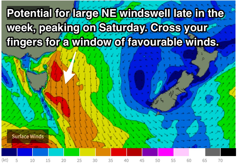
The next best chance of swell comes late in the week as a gusty northerly fetch develops over eastern parts of Bass Strait. Friday will really see this northerly fetch ramp up in both intensity and area. We are looking at 30-35kt breezes hugging the Tasmanian coast, extending virtually all the way to Eden by midnight on Friday.
Open beaches should see a northeasterly windswell build strongly to the 4-6ft range by the afternoon, although heavily wind affected.
This weekend (Saturday 26th - Sunday 27th):

Following the peak of northerly breezes overnight, Saturday is looking at the peak in northeasterly swell, with open beaches potentially moving into the 6ft+ range at dawn, fading thereafter. A distinct southerly change looks to rip up the coast sometime in the morning, with a period of light winds preceding. Assuming there isn't a whole lot of scarring (which is a prety high chance) there may be some great options across the open beaches. Following this change, protected southern corners will be the go.

