NE swell looking good for Sunday
Eastern Tasmania Surf Forecast by Guy Dixon (issued Friday 18th December)
Best Days: Sunday, possibly Tuesday afternoon.
Recap:
We've seen small options breaking along the open beaches over the past few days, generated by a modest northerly fetch off the coast of southern NSW. Conditions have been clean each morning under light/variable-offshore breezes, but slightly undersized in the 1-2ft range.
This weekend (Saturday 19th - Sunday 20th):
We are looking at a small mix of swell for the start of the weekend, with most spots offering options in the 1-2ft range.
South facing beaches are looking to make the most of back ground southeasterly energy, while open beaches are expected to pick up hints of a northeasterly windswell generated by a small fetch which extended from the NSW South Coast, across eastern Bass Strait on Thursday.
Conditions look to be clean early under a light/variable airflow, tending light northeasterly in the afternoon, limiting options to protected northern corners of south facing beaches.
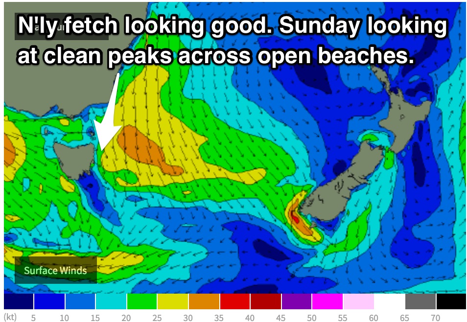
 A northerly fetch is still on track to increase along the coats of NSW and eastern parts of Bass Strait on Saturday, providing an increase in northeasterly swell for the open beaches on Sunday.
The surf should build to the 2-3ft range, with workable conditions throughout the day. The early session is looking at light northerly breezes, increasing in the afternoon while tending northwesterly. You shouldn’t have much trouble finding a clean set up around St Helens, however afternoon breezes have the potential to be dicey further south around Bicheno.
Next week (Monday 21st onward):
Monday is looking like a dynamic day, with open beaches fading from the 2ft range off the back of a northeasterly swell.
Meanwhile, a front looks to pass over the state adding a small amount of southerly windswell into the mix. Exposed south facing beaches have the potential to build to the 1-2ft range by the afternoon, however the quality isn’t likely to be amazing, with southwesterly breezes tending southeasterly as the swell builds.
Tuesday holds much better prospects for a decent groundswell, with the impacts of the core fetches filling in.
The system responsible for this pulse of groundswell doesn’t look as good in the latest model runs, with very intense, but small core fetches moving rapidly in an easterly direction. The transient nature of this system means that it’ll pass through the swell window without much swell generating time.
Nevertheless, we can expect south swell magnets to build to the 2-3ft range during Tuesday, although likely hampered by a less than favourable moderate southerly airflow, easing and tending easterly throughout the day.
The late afternoon session should see the best conditions, assuming the swell sticks around long enough.
Further ahead, a Tasman ridge looks to replace this front and low as it moves southeast, allowing yet another northerly fetch to set up off the South Coast of NSW starting the cycle over again.

