Open beaches hold the best options in coming days
Eastern Tasmania Surf Forecast by Guy Dixon (issued Wednesday 2nd December)
Best Days: Friday morning, Saturday at protected corners and possibly Tuesday.
Recap:
Conditions remained clean throughout Tuesday under a persistent offshore breeze while a 2ft northeasterly swell rolled in. This morning, the swell had eased back a touch, more in the 1-2ft range at open beaches, but conditions remained clean under a northwesterly airflow. A seabreeze has since kicked in however, so the quality has dropped.
This week and weekend (Thursday 3rd - Sunday 6th):
East/northeasterly trade-swell is likely to be the most dominant swell in the water over coming days, with any southerly energy negligible due to the direction.
A westerly airflow has been dominating the region in the wake of a cold front, however the resultant swell has poor alignment and is not expected to generate any noticeable size for even the most exposed south swell magnets.
In this case, we cast our eyes to the northern/eastern swell windows for the best chances of surf.
Tropical Cyclone Tuni has been lingering over the tropical South Pacific over the past few days, but has now moved out of our swell window. Nevertheless, the impacts from this system are well delayed, and we can make the most of it’s effects in the coming days.
Thursday is likely to be undersized, with open beaches picking up a fairly insignificant 1ft of east/northeasterly energy. On the plus side, light breezes look to prevail form the northwest early, holding into the afternoon north of St Helens. Further south, breezes look to tend north/northeasterly in the afternoon.
This swell should then build throughout Friday, likely peaking on Saturday morning, with very inconsistent sets in the 2ft range at open beaches (majority of the surf in the 1-2ft range).
Friday is looking at light/variable winds in the morning, tending onshore but remaining light throughout the day. Saturday will be confined to protected southern corners of the open beaches, as a gusty southerly breeze dominates the coast.
Sunday is likely to see a gradual easing trend from the 1-2ft range throughout the day, under a light northeasterly airflow.
Weak frontal activity passing over the southern Tasman on Friday and Saturday will add a tiny amount of southerly energy into the mix for Sunday afternoon, however it’s impacts will be subtle. South facing beaches should only see around 1-2ft off this swell.
Next week (Monday 7th onward):
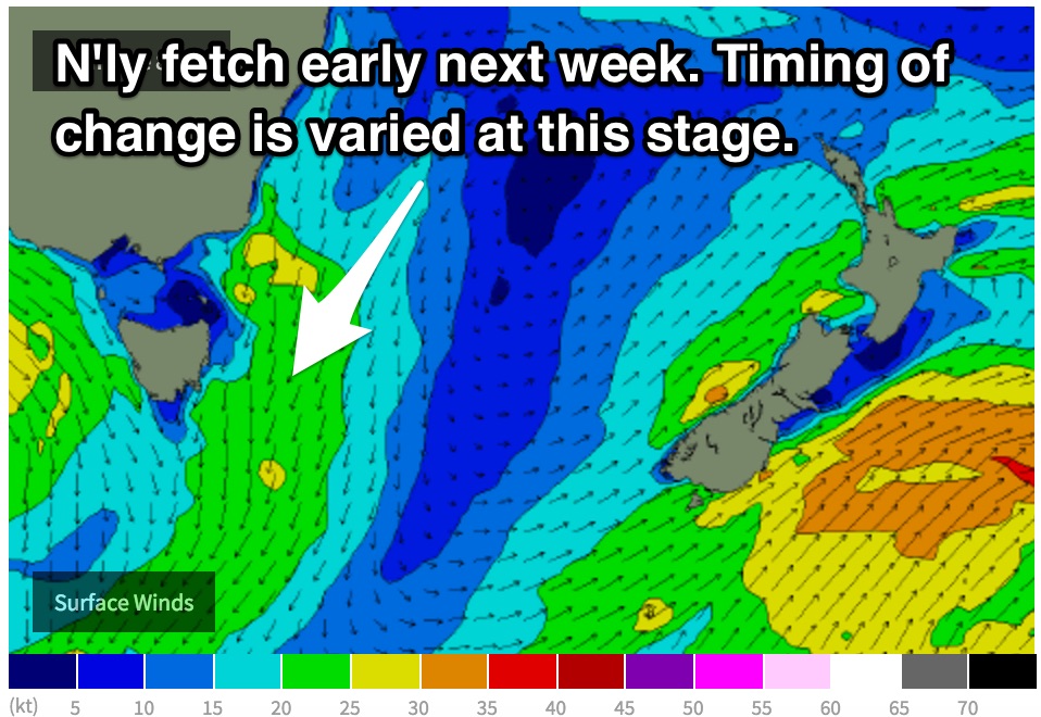
 Trade-swell will continue to gradually ease during the early stages of next week, however a more local northerly fetch looks to set up along the far South Coast of NSW and eastern Bass Strait on Monday and Tuesday morning.
A local northeasterly windswell is expected to build to the 2ft range late on Monday at open beaches, peaking on Tuesday in the 2-3ft range.
Conditions aren’t expected to be all that crash hot on Monday, as the same winds responsible for the swell will also be impacting the quality.
However, Tuesday holds better prospects with the chance of winds tending northwesterly ahead of a southerly change. Models are still disagreeing on the timing of this change, so the opportunity of a wave remains up in the air.

