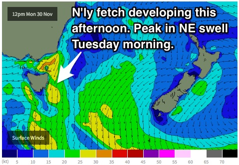
NE swell Tuesday, small until the end of the week
Eastern Tasmania Surf Forecast by Guy Dixon (issued Monday 30th November)
Best Days: Tuesday, possibly Friday afternoon
Recap:
Exposed south magnets picked up a small southerly swell in the 1-2ft range generated by poorly aligned local frontal activity on Saturday, much smaller elsewhere. Northwesterly breezes allowed for clean conditions during the morning, deteriorating as a seabreeze kicked in during the afternoon. Sunday saw the swell fade to just a hint of southerly energy, although remained clean until the late morning.
Open beaches have been offering clean, workable conditions in the 1-2ft range off a northeasterly swell today, with northwesterly breezes persisting.
This week (Tuesday 1st - Friday 4th):
 A deep trough over the Australian landmass is moving east and interacting with a strong Tasman ridge allowing a northerly airflow to increase over eastern parts of Bass Strait this afternoon and into this evening.
Open beaches are expected to build to the 2ft range this afternoon, however local breezes are forecast to tend northerly and increase, tending north/northeasterly at times. As a result, the quality of the surf is expected to be poor, with much better prospects for Tuesday morning.
This northeasterly swell is likely to be at it’s largest on Tuesday morning, offering 2-3ft peaks across the open beaches. By this stage, the trough and weak front responsible for generating this swell will have moved east, allowing for a northwesterly airflow to dominate the coast.
We are looking at clean, peaky conditions for the morning session on Tuesday under a light/moderate northwesterly breeze. As the day progresses, these breezes are likely to increase and possibly swing further north, however conditions are expected to remain easily workable.
A front and associated low are then forecast to move over the region late on Tuesday into the early hours of Wednesday, steering a west/southwesterly flow over much of the state.
Due to the poor alignment and local nature of this system, we can only expect the exposed south swell magnets to pick up around 1ft off southwesterly trailing fetches, virtually nothing elsewhere.
Background east/northeasterly energy should otherwise be the main source of energy for open beaches.
On the plus side, winds are expected to be light/variable in the morning, tending southwesterly during the day, keeping conditions workable at most locations throughout the day.
The surf is then expected to fade further on Thursday with only tiny hints of east/northeasterly energy filling in. The source of this long range east/northeasterly energy is from a tropical depression over the tropical South Pacific which has now developed into Tropical Cyclone Tuni.
Friday will see an increase in this long range swell, generated from a slight intensification of this system earlier in the week. Open beaches are expected to build from around 1ft to the 2ft range by the afternoon. Consistency is likely to be an issue however, as the source of this swell is so far away. The sets will be well ordered, but very inconsistent with long waits in between.
Winds look to be light and variable for the morning of Thursday and Friday, with sea breezes developing each afternoon. The seabreeze only looks to be light each afternoon, so conditions should remain easily workable.
This weekend (Saturday 5th - Sunday 6th):
Saturday is likely to see the peak of this inconsistent east/northeasterly swell before gradually fading throughout Sunday. The afternoon of Saturday can expect the majority of the surf to be in the 2ft range, with the odd bigger set every so often. Sunday is then expected to fade from the 2ft range.
Unfortunately, early indications show Saturday to be under a southerly flow, tending southeasterly during the afternoon. Therefore, protected southern corners should be the first port of call for the cleanest options. This onshore flow is expected to ease and gradually swing northeasterly throughout Sunday.

