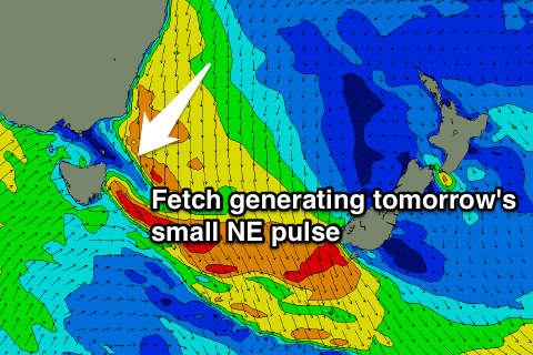
Small NE swell Thursday with favourable winds
Eastern Tasmania Surf Forecast by Guy Dixon (issued Wednesday 25th November)
Best Days: Thursday afternoon, small each day thereafter but with favourable winds. Possibly Tuesday and Wednesday
Recap:
Conditions have been clean all day yesterday and today under persistent offshore breezes, but there is an apparent lack of surf. Only the south swell magnets have been picking up options, even then, undersized and weak.
This week (Thursday 26th - Friday 27th):
A deep inland trough is currently moving over inland NSW and is interacting with a strong ridge over the Tasman Sea. A northerly airflow is currently increasing off the coast of NSW whipping up a northeasterly swell due for open beaches on Thursday.
The alignment of this system is not ideal and the main fetches are moving fairly quickly in an eastward direction, so the duration of swell generation brief. As a result, however, Thursday afternoon should see a peak in size at around 2ft at open beaches.
In the wake of this trough and associated cold front on Thursday, gusty west/southwesterly fetches to the south will also add an element of southerly energy into the mix. This swell is by no means ideal due to the amount westerly component, swell so only the most exposed south swell magnets are expected to pick up inconsistent sets in the 1ft range. Most spots will be lucky to get anything at all.
Local breezes are likely to prevail from the west throughout the day, so there should be clean options along virtually all coasts no matter when you’re available for a paddle. Just take a board with plenty of foam for the best chances.
The northeasterly swell is likely to fade on Friday, with open beaches easing from the 1-2ft range. Gusty west/southwesterly fetches persisting to the south will maintain a tiny amount of southerly energy at the magnets, however again, it’s alignment is be poor.
On the plus side, conditions look to remain clean at most conditions throughout the day under a light west/northwesterly breeze persisting all day.
This weekend (Saturday 28th - Sunday 29th):
Background southerly energy generated from higher latitudes will maintain a tiny amount of southerly energy at the magnets, although generally ebbing and pulsing between a weak 1-2ft on Saturday and Sunday.
The morning session on Saturday is looking good under light/variable winds, however an afternoon sea breeze is then expected to increase from the northeast. Sunday is looking to remain generally light and variable for most of the day.
Next week (Monday 30th onward):
The long term outlook is hinting at another sizey northeasterly windswell as another trough/front interacts with a strong ridge.
At this stage, models suggest a north/northeasterly breeze to increase along the coast, to a peak late on Tuesday. This would mean open beaches have could build to 3ft on Tuesday afternoon, further on Wednesday morning.
Being mindful of making a call to early with a changeable forecast, it looks like wind should cooperate for this event, should everything go to plan. More detail on Friday.

