South swell magnets the pick for Tuesday
Eastern Tasmania Surf Forecast by Guy Dixon (issued Monday 16th November)
Best Days: Tuesday morning, Wednesday morning, possibly Friday and Saturday morning.
Recap:
Saturday morning looked fun right along the coast with clean 2-3ft options under light northwesterly breezes until mid morning. Breezes then swung southeasterly causing conditions to gradually deteriorate. The northeasterly swell faded into Sunday, while southerly breezes overnight whipped up a short range southerly swell to a similar size, around the 1-2ft mark. There was a small window in the morning of light offshore breezes, but conditions then turned as a northeasterly seabreeze kicked in during the mid-late morning.
A lot of the swell has dried up today. We have small dribbles of swell in the 1-2ft range which were clean earlier, however breezes have swung onshore and it seems to be all over for today.
This week (Tuesday 17th - Friday 20th):
A frontal progression moving over southern parts of the Tasman sea/Southern Ocean today is steering southwesterly core fetches of around 35-40kts. The alignment isn’t perfect, however they’re better than what we have seen in the past few weeks so we can look forward to an increase in groundswell at the across south swell magnets on Tuesday.
Due to the slight amount of west in the direction of the swell, only the most exposed south swell magnets are likely to pick up this southerly energy. Elsewhere will have to rely on refracted energy and therefore are likely to be a fair bit smaller. Sets are expected to build into the 2-3ft range by the middle of the day on Tuesday.
Open beaches should also see small lift in size to the 1-2ft range by the afternoon generated by a weak northerly fetch increasing over eastern parts of Bass Strait throughout the day. Winds are forecast to be light north/northwesterly early, swinging northerly before tending north/northwesterly again and increasing in the late afternoon. These gusty breezes in the afternoon have the potential to cause a few issues at open beaches in the afternoon, so keep your expectations grounded.
Wednesday is likely to see each swell fade gradually to the 2ft range at south facing beaches, and the 1ft range elsewhere. However winds look to prevail from the west early, remaining light into the afternoon. Periods of northeasterly breezes are likely in the early-mid afternoon, particularly in the north, however light enough to not cause too many concerns.
Much of Thursday will have to rely on residual energy in terms of surf. Light westerly breezes are forecast early, increasing from the northwest throughout the day as a deep trough and associated low move over the region. Winds have the potential to be fresh/strong in the afternoon, however their direction is not likely to generate any significant swell.
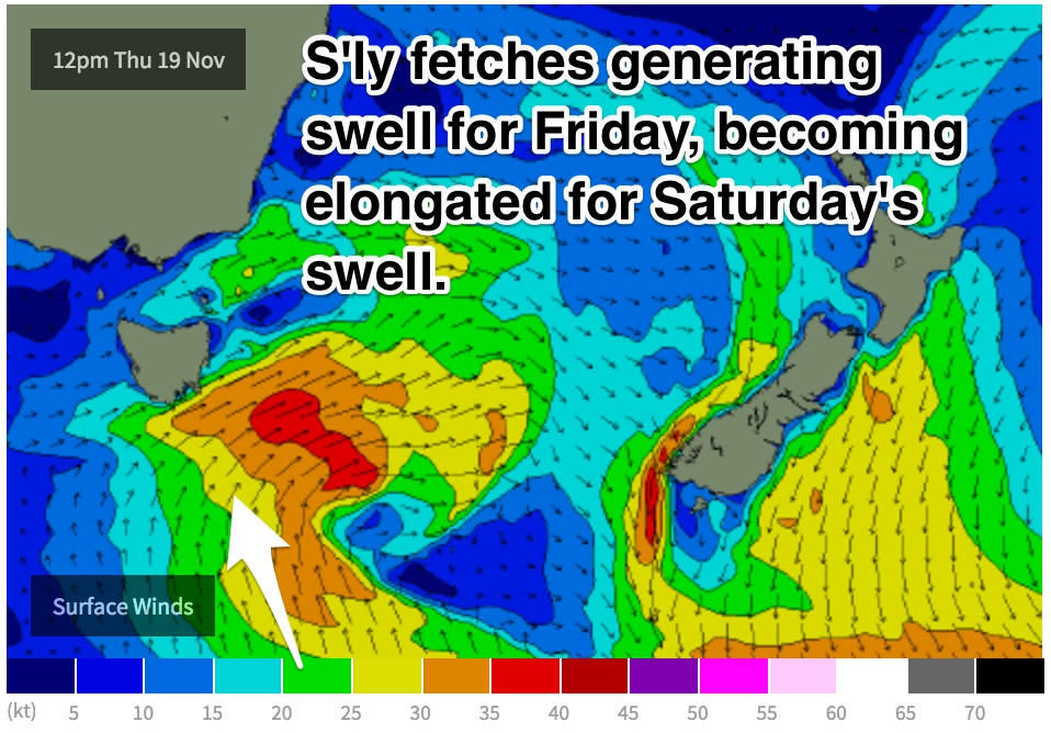
 The most significant swell generating part of this system will likely be further south with southerly fetches of around 25-30kts. We can expect south facing beaches to pick up surf in the 2ft range on Friday afternoon. The timing is fairly flukey. We are hoping for the energy to fill in earlier when winds will be light/variable, however it looks as though an afternoon seabreeze will increase as the size pushes in.
This weekend (Saturday 21st - Sunday 22nd):
As this southerly swell source moves east, a southeasterly fetch will become elongated, but maintain the influx of southeasterly swell. We should see a peak at south facing beaches in the 2ft+ range on Saturday morning, easing in the afternoon.
Winds are forecast to be light westerly throughout the morning, tending moderate southeasterly in afternoon.
The outlook further ahead looks dicey with a fair amount of model uncertainty in the mix. Best off holding out on the details until models come into alignment.

