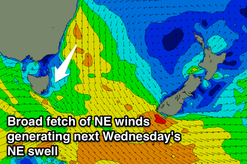
Potential for a workable NE swell Wednesday
Eastern Tasmania Surf Forecast by Guy Dixon (issued Wednesday 14th October)
Best Days: Wednesday morning
Recap:
Conditions were small and clean throughout yesterday under light variable winds early which increased from the west in the afternoon. Small peaks in the 1ft range have built to the 1-2ft range off a northerly fetch sitting offshore. Conditions remain equally as clean today under light/moderate westerly component breezes.
This weekend (Saturday 17th - Sunday 18th):
A northerly fetch sitting offshore will lose definition and be excluded to the west by a cold front approaching from the west. This northerly fetch has been the most significant swell generator in the past few days, so once it breaks down, the swell will taper off.
Saturday is likely to fade back to the 1ft range across most coasts preceding the next small pulse of swell. Fresh northwesterly winds also have the potential to iron out any small lines of energy.
A strong front is set to move over the region on Saturday afternoon/evening steering poorly aligned southwesterly trailing fetches of 35-40kts through the southern swell window. Side-band energy off this system will be subtle, however south facing beaches can expect peaks building into the 1-2ft range on Sunday afternoon. Light/moderate winds are likely to prevail from the south early, tending southeasterly in the afternoon.
Next week (Monday 19th onward):
Southerly swell off the aforementioned front will continue to filter in across south facing beaches on Monday morning in the 1-2ft range, easing throughout the day under increasing northerly breezes. Back ground energy will keep the surf in the 1ft size throughout Tuesday under northerly breezes.
 The swell window will remain generally dormant otherwise until a more significant northerly fetch sets up off the NSW far south coast and eastern Bass Strait on Monday afternoon. At first, this system looks to be modest, however some models suggest an strong increase in winds off the NSW coast on Tuesday. This system has the potential to provide a much healthier, longer range northeasterly swell for northeast Tasmania on Wednesday.
We hope to see peaks in the 2ft range across open beaches on Wednesday, that’s if this strong northerly scenario comes off. There is an element of model disagreement, but models will come into alignment with time.
A local southerly swell is also likely to kick up on Wednesday afternoon with the passage of a front throwing an element of short range southerly swell into the mix. The morning session looks good under light west/northwesterly breezes ahead of the gusty southerly change.
Multiple weak frontal progressions will move to the south of Tasmania late in the week maintaining a steady flow of small southerly swell for the magnets. The surf should drop below 1-2ft at south facing beaches for the remainder of the week.

