Large swells with workable winds
Eastern Tasmania Forecast by Craig Brokensha (issued Friday 28th August)
Best Days: Protected spots over the coming period and more exposed breaks from Tuesday
Recap
Fun levels of S'ly groundswell and new NE swell yesterday with morning offshores, while today the NE swell was on the ease with a building stormy S/SE swell as a vigorous polar front projects up into the south-east corner of the state.
 This weekend and next week (Aug 29 – Sep 4)
The models have been moving around a lot regrading the strong polar front that's currently pushing up and into our coast, with Wednesday's updates having it further west and out of our swell window.
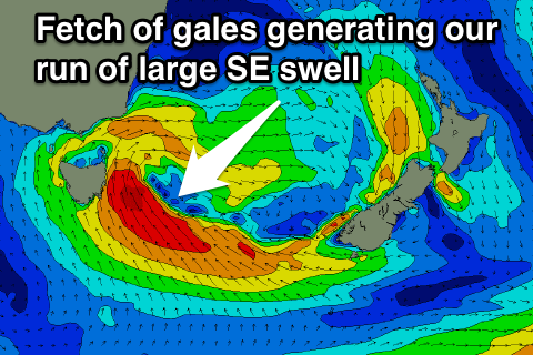
Alas it is now impacting the coast and while combining with the remnants of the East Coast Low off the Southern NSW coast, will project a fetch of gale to severe-gale SE winds into us this evening and tomorrow, generating a large and stormy S/SE swell.
South facing beaches should kick to an easy 8ft later tomorrow, much smaller through the morning. A strong S/SE wind is due just on dawn and this will swing more S'ly through the day, so you'll have to suss out protected spots for a wave, but expect much less size here.
The initial large S/SE groundswell pulse will then back off into Sunday while being reinforced by some new SE swell, generated by a broad and persistent fetch of strong to gale-force E/SE to SE winds aimed in our swell window through the Southern Tasman Sea all weekend.
Exposed spots should ease from 6-8ft Sunday morning but not drop below 6ft and then ease very slowly from 4-6ft Monday morning, with one final E/SE pulse Tuesday to 4-5ft, fading slowly through Wednesday and Thursday.
Winds will remain from the S/SW tending S'ly Sunday and then S'ly tending S/SE Monday, favouring protected spots.
Tuesday should see light offshores and weak afternoon sea breezes, with a similar trend due through the rest of the week.
Longer term there's nothing major on the cards, so make the most of the coming swell event. Have a great weekend!

