Poor weekend, better S'ly swell next week
Eastern Tasmania Forecast by Craig Brokensha (issued Friday 14th August)
Best Days: Tuesday morning, Wednesday, Thursday afternoon, Friday
Recap
Tiny 1ft of background east swell with favourable conditions.
This weekend and next week (Aug 15 - 21)
A weak S/SW change overnight should kick up a weak S'ly windswell to 1-2ft across south swell magnets tomorrow morning. This will ease through the day under variable tending N'ly winds.
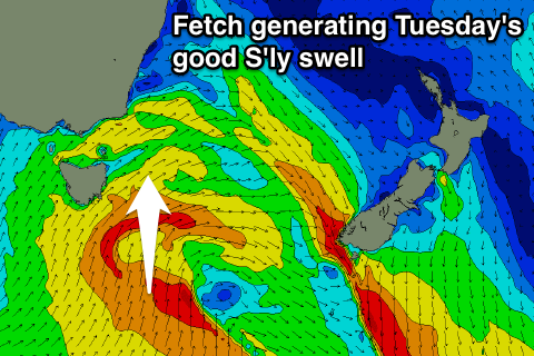
Of greater importance is the S'ly swell due early next week.
 A vigorous polar low will push up and across the state on Monday, directing a fetch of gale to severe-gale SW winds through our swell window, followed by a better, broader but weakening S/SW fetch Tuesday morning.
We should see an initial spike in S'ly groundswell Monday afternoon but only to 2ft max across south facing beaches later in the day.
A better S'ly swell is then due Tuesday with 3-5ft sets across south facing beaches and 2-3ft sets at open beaches.
The swell will then ease slowly through Wednesday from 3ft+ across south facing beaches from the S/SE.
Now, winds Monday are expected to be from the W/SW tending SW with W/SW tending S/SW breezes Tuesday at the peak of the swell, which is less than ideal.
Wednesday looks much better with W'ly tending E'ly breezes as the swell eases from the S/SE.
Into the end of the week, one final pulse of good S'ly groundswell is due to build Thursday afternoon and ease Friday, generated by a vigorous polar frontal system forming under the state through next week.
This should provide a good kick to 3-4ft across south facing beaches with favourable NW tending N'ly winds. As the swell drops, N'ly winds should keep south swell magnets clean.
Longer term there's nothing too major on the cards, but we'll review this Monday. Have a great weekend!

