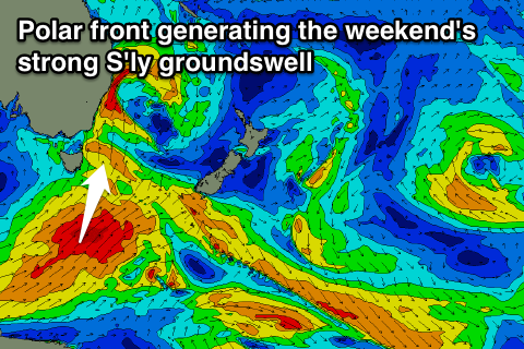
Plenty of S'ly swell, best Sunday
Eastern Tasmania Forecast by Craig Brokensha (issued Wednesday 15th July)
Best Days: Thursday morning, early Friday, Saturday morning, Sunday
Recap
Solid mix of easing E/NE and S'ly swell yesterday but with poor winds, best for protected southern corners.
Today the swell was smaller from the E/NE with 2-3ft waves across most spots with better winds. A new S/SE swell should of kicked into the afternoon to 3-5ft across south facing beaches.
 This week and weekend (Jul 16 – 19)
This afternoon's kick in S/SE swell should ease back through tomorrow from 3-4ft and then further from 2ft+ Friday morning.
Winds are looking alright with a morning W'ly, tending S'ly breeze and then W/NW tending strong S'ly winds Friday.
Friday's S'ly change will bring with it a fresh kick in S'ly windswell for the afternoon, with a stronger S'ly groundswell pulse for Saturday, peaking into the afternoon.
This will be generated by a strong fetch of S/SW gales projecting north-east up through our southern swell window tomorrow evening and Friday.
South facing beaches are expected to build to 3-5ft Saturday afternoon and then ease into Sunday from 3-4ft.
Winds Saturday will be average and from the W/SW tending S/SW with great NW winds Sunday.
Into next week the S'ly swell will fade under offshores, and there's nothing significant on the cards for the rest of the week. We'll provide another update on this Friday.


Comments
Hi Craig,
Are you able to say anything more about the timing of the S-change on Friday ?
thanks
Hi Truda, the change looks to be hitting EHN just after 7am and basically up the whole coast by 10am.
Hi Craig, it seems you posted the Tassie forecast into the Surfcoast box - I'd really like a surfcoast forecast, as I'm not taking the ferry down to Tas tonight. :-) Cheers
Ah, thanks for pointing this out, changed.
still looks crapola for tomorrow anyway! Hopefully the update is better news!!! thanks