Large S/SE swell with improving conditions
Eastern Tasmania Forecast by Craig Brokensha (issued Monday 1st April)
Best Days: Thursday afternoon/evening in protected southern corners, Friday morning, Saturday morning, Sunday morning, Monday in southern corners
Recap
Flat with no options for a surf.
 This week and weekend (Apr 2 - 5)
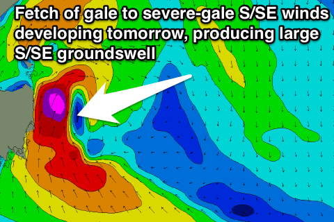
As touched on last update, the coming period revolves around the developments of a deepening surface trough and intense low pressure system forming off our coast tomorrow.
We're now right on the doorstep of this development, with large stormy surf due to develop through tomorrow before easing off from Friday while becoming cleaner.
Early tomorrow morning a gale-force S/SE change is due to move up the coast, probably well and truly in by 8am.
During the day winds are forecast by some models to reach the severe-gale force range and this would kick up a very large and stormy S/SE swell through the afternoon and evening.
Even if winds are a touch weaker, we're still looking at east 6-8ft surf across south facing beaches on the upper half of the East Coast (smaller in EHN) but with poor and strong to gale-force S'ly winds. A late swing in winds to the S/SW will open up options in southern corners for keen and experienced surfers.
The low is expected to start drifting off to the south-east on Friday but there'll still be a fetch of S/SE gales aimed in our swell window through the morning.
This will result in the swell remaining large out of the S/SE Friday morning to 6ft to possibly 8ft across south facing beaches on the upper half of the East Coast, with 4-6ft sets at open beaches.
A slow drop in size is expected through the afternoon as the swell swings more SE, dropping away further 3ft to occasionally 4ft Saturday morning, down to 2ft+ through the day.
Come Sunday there isn't expected to be any real size left with fading 1-2ft waves.
With the low drifting south-east winds will improve swinging offshore from the W/SW and then back to the S/SE into the afternoon.
Saturday should then see light offshore winds and afternoon sea breezes, with Sunday seeing NW tending N/NE winds and an afternoon increase in NE windswell to 2-3ft or so.
Into next week fun levels of NE swell are due from a deepening Tasman Low Sunday, aiming a strengthening fetch of NE gales through our swell window.
Firstly some NE windswell should ease from 2-3ft across north-east facing beaches Monday morning, with a S'ly change moving through, favouring these locations. While the NE groundswell is due Tuesday morning to an inconsistent 3ft.
Longer term we're likely to see another deepening low off the Southern NSW Coast mid next week kicking up building levels of S/SE swell but more on this Friday.

