Tiny weekend, much more action next week
Eastern Tasmania Forecast by Craig Brokensha (issued Wednesday 14th January)
Best Days: Tuesday morning, south swell magnets, Wednesday protected northern corners (out of the wind and swell), Thursday, Friday morning
Recap
Tuesday's strong NE groundswell pulse eased back into yesterday as a new S/SE swell came in at 3-5ft across exposed breaks. Winds from the southern quadrant early favouring southern corners before sea breezes kicked in.
Today a mix of easing SE and E/NE swells continued to offer 2-3ft waves, but a further drop to 1-2ft should have been seen through the day.
This weekend and next week (Jan 17 -23)
Today's mix of swells should fade overnight with only tiny offerings due into tomorrow morning. The rest of the weekend isn't looking much better with tiny to flat surf expected.
A small S'ly groundswell pulse for Monday morning is still on track with a vigorous and slow moving frontal system due to aim a weakening fetch of SW tending S/SW gales off the south-east corner of our state overnight Sunday and into Monday.
This should produce a moderate pulse of S'ly groundswell across south swell magnets Monday, coming in at 3-4ft. This swell should ease through the afternoon, but a better reinforcing S/SE swell is due into Tuesday morning.
The source of this swell will be a broad fetch of strong S/SE winds being projected up towards us, wrapping around the southern flank of the frontal system.
This should keep south facing breaks kicking in the 3ft+ range with 2ft+ sets at open beaches during the morning before easing into the afternoon.
Winds will be an issue Monday though with a fresh SW tending SE breeze, creating poor conditions at south swell magnets. Tuesday should be cleaner at dawn, but you'll have to be quick as an early N/NW'ly is due to strengthen from the N/NE.
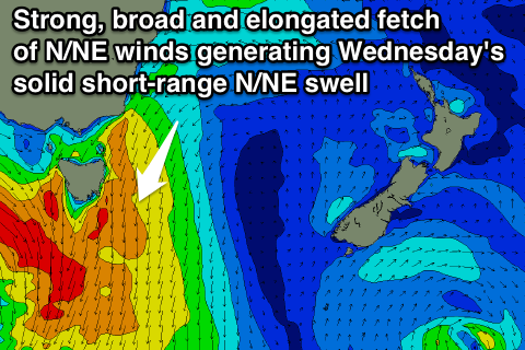
 Moving into Wednesday, our solid increase in short-range N/NE swell is still on track with a broad, elongated and strengthening fetch of NE winds due to develop through Tuesday and reach a peak in intensity just before dawn Wednesday.
A solid but acute short-range N/NE swell is due, coming in at 4-6ft at north-east swell magnets Wednesday morning. Remaining beaches are due to be smaller and in the 3ft+ range.
Winds will be poor and strong from the N'th Wednesday morning before improving later and swinging N/NW as the swell backs away.
Thursday looks much cleaner and good for open beaches with a W/NW breeze and secondary pulse of NE swell to 3-4ft as a broad fetch of strong NE winds persist off the Southern NSW coast.
This fetch is due to weaken later in the week, but we may see a tropical depression drifting south from the Coral Sea, into the central Tasman generating more NE swell for the weekend and following week, but more on this Monday. Have a great weekend!

