Good southerly swells Friday through Sunday

Eastern Tasmania Forecast by Craig Brokensha (issued Wednesday 26th November)
Best Days: Friday morning, Saturday morning and Sunday morning at south swell magnets
Recap
Tiny to flat surf continued yesterday and today, but some new south swell is on the way.
 This week and weekend (Nov 27 - 30)
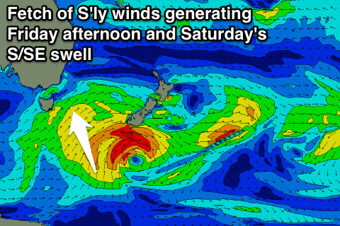
Our pulses of S'ly swell due tomorrow afternoon and into Friday are still on track, with a strong cold front pushing up past the coast today due to be followed by a secondary more favourable system this evening and early tomorrow.
This should kick up a 2ft to nearly 3ft of S'ly swell across south facing breaks during tomorrow afternoon but with unfavourable SE winds.
A drop in size is due through Friday from 2ft to nearly 3ft, and a reinforcing S/SE swell is due to keep similar sized sets hitting the coast into the afternoon and Saturday, generated at the base of the parent low that's spawning each cold front.
This low today generated a fetch of strong to gale-force S'ly winds through our southern swell window, and will continue to do so this evening and tomorrow morning before shifting off towards New Zealand.
This should keep 2ft to nearly 3ft sets hitting south swell magnets into Saturday morning before easing into the afternoon.
Winds will be favourable for these locations from Friday with a W/NW tending E/SE breeze and then variable tending NE wind Saturday.
Into Sunday our good pulse of refracted long-period S'ly groundswell is still on track, with a strong polar low skirting around the base of a strong blocking high to our west due to produce a fetch of severe-gale W/SW winds in our swell window before pushing up towards New Zealand.
This swell should peak Sunday morning to a good strong 3ft across south swell magnets under strengthening NE tending E/NE winds. So you'll need to seek some protection out of the wind to get the cleanest conditions. Also surf early as the swell will ease steadily during the day.
Next week onwards (Dec 1 onwards)
Into the start of next week we've got some building but junky NE windswell on the cards as a deepening surface trough moving offshore aims a strong fetch of E/NE winds towards us from Sunday afternoon through Monday before possibly slipping away to the south-east overnight.
This will kick up moderate levels of E/NE windswell and once the system slips south we should see winds swing offshore.
When and if this scenario takes place will have to be reviewed on Friday so check back then for an all important update.