Best Wednesday morning and Thursday

Eastern Tasmania Forecast by Craig Brokensha (issued Monday 10th November)
Best Days: Wednesday, Thursday and Friday morning at south swell magnets
Recap
Saturday started tiny but a small kick in windswell was seen later through the day before fading Sunday with onshore SE winds. Today tiny surf was seen across the coast, but we've got some better S'ly swell on the way.
 This week (Nov 11 - 14)
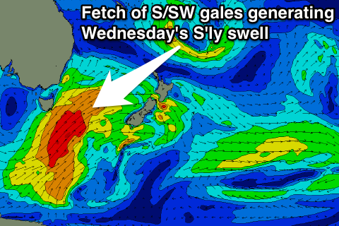
We should see two solid pulses of S'ly swell across the coast over the coming days, the first tomorrow not being as favourable and from a fetch of SW gales being projected up past us this evening and tomorrow morning.
A better fetch of S/SW winds on the backside of the front during tomorrow should generate a larger and better S'ly groundswell pulse for Wednesday.
Tomorrow's increase should build through the day, coming in at 3ft across south facing beaches into the afternoon (smaller early), while Wednesday morning's pulse should reveal better 3-5ft waves across exposes south facing breaks before easing through the day.
Winds tomorrow will be average and fresh from the SW tending S/SE, while Wednesday should see light W/NW tending NE winds, favouring those northern corners.
Our good pulse of S/SE groundswell for Thursday morning has unfortunately been downgraded a touch with the fetch of S'ly gales on the base of the front pushing across the state not forming as favourably as looked late last week.
We should still see south facing breaks holding the 3ft range Thursday morning before tailing off later in the day and further from 2ft Friday.
Winds should be favourable and from the NW to N/NE again, with Friday seeing W/NW offshores ahead of a S/SE change.
This weekend onwards (Nov 15 onwards)
In the wake of Friday's change a funky trough is forecast to deepen directly to our north-east and this should aim a fetch of SE gales on the edge of our swell window, likley kicking up a weak S/SE windswell for later Saturday and Sunday.
This doesn't look to reach any major size at this stage before it pushes off quickly to the east resulting in a rapid drop in swell.
Longer term small pulses of S'ly and NE swells are on the cards but to no major significance. More on this Wednesday.