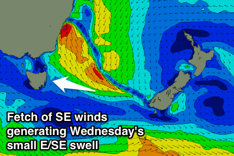
Best Wednesday and Thursday mornings with an E/SE swell
Eastern Tasmania Forecast by Craig Brokensha (issued Monday 13th October)
Best Days: Wednesday morning, Thursday morning
Recap
The weekend didn't offer any love surf wise, and today an onshore change created poor conditions with tiny amounts of swell. Some small NE swell should of made its way down towards us through the day but options would have been limited to southern corners with the strengthening southerly breezes.
This week (Oct 14 - 17)
A surface trough moving across the state and deepening is the system responsible for the poor winds and weather developing during today and this should provide us with S/SE tending SE and then E/SE swell over the coming days.
 The trough is forecast to deepen off the Southern NSW Coast, projecting a fetch of S/SE gales into Sydney south. To our east the fetch will be in the strong to gale-force range and just within our swell window, with local levels of S/SE windswell today expected to ease through tomorrow and swing from the SE later tomorrow to the E/SE Wednesday.
South facing locations should ease from the 3ft range tomorrow morning with 1ft+ waves at open beaches with poor S/SW tending SE winds.
Wednesday morning looks better with the E/SE swell building from 2ft+ across open beaches to 3ft through the afternoon with SW tending E/SE winds.
The weather system will break down through Wednesday resulting in a drop in swell from the 2-3ft range across open beaches through Thursday with offshore W'ly winds ahead of a strong S'ly change. There should also be small levels of NE swell in the mix tomorrow, Wednesday and Thursday morning but too no major size.
Thursday's S'ly change into the afternoon will be related to another deepening surface trough moving in from the west and across us and no major S'ly swell is expected off this at all.
This weekend onwards (Oct 18 onwards)
We're looking at some better N/NE windswell into Sunday morning but more so Tuesday next week as a couple of troughs drifting in from the west interact with high pressure systems developing in the Tasman Sea, but more on this Wednesday.

