Flat until some better NE swell fills in next week
Eastern Tasmania Forecast by Craig Brokensha (issued Wednesday 8th October)
Best Days: Monday and Tuesday
Recap
Yesterday was fun across north-east swell magnets with an easing N/NE windswell from 2-3ft with favourable winds. Today the surf was tiny with no options for a wave.
This week and weekend (Oct 9 - 12)
There's nothing major on the cards running into the end of the week unfortunately with a tiny S'ly swell tomorrow not expected to amount to much, while Friday will be near flat.
Saturday will start out similarly with effectively flat surf across the coast and Sunday the same, with a strong W/SW groundswell filling into the South Arm during the afternoon not expected to offer any major size across our coast with it being too west in nature.
Next week onwards (Oct 13 onwards)
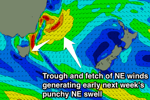
 We've got some better activity on the cards for next week as a surface trough drifting in from the west, squeezing against a strong high in the Tasman Sea Sunday, expected to produce a punchy NE swell.
A broad and elongated fetch of strong to gale-force NE winds are expected to be aimed within our swell window Sunday and early Monday, producing a moderate sized NE windswell.
This swell should show through Monday, coming in at 2-3ft across north-east facing beaches with fresh W/NW winds, with a stronger pulse of short-range NE swell due Tuesday to 3-4ft as winds swing S'ly with strength (kicking up fresh levels of S'ly swell).
The models are still moving around regarding the make up of the fetch through our swell window, so check back here on Friday for an update on this.

