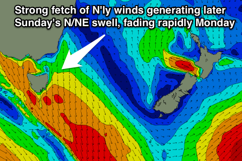
Junky windswell developing late Sunday, fading Monday
Eastern Tasmania Forecast by Craig Brokensha (issued Wednesday 24th September)
Best Days: No good days, desperate surfers late Sunday and early Monday
Recap
No surf to speak of with Monday's SE swell fading completely leaving tiny peelers across the coast.
This week and weekend (Sep 25 - 28)
 Tomorrow will remain tiny as well as Friday and Saturday with the next noticeable movement across the coast due through Sunday afternoon. This will be in the form of a weak and building N/NE windswell as a strong cold front pushing in from the Bight, squeezes a strong high in the Tasman Sea, producing a broad and strengthening fetch of N'ly winds through our swell window.
The direction of the winds isn't ideal but we should still see small levels of N/NE windswell spreading out radially towards us later Sunday before easing rapidly Monday as the front pushes through.
North-east facing beaches are due to reach 2-3ft late Sunday with strong N'ly winds, while Monday will be lucky to see 1-2ft leftovers as strong W/NW winds kick in.
Longer term there's nothing major on the cards besides a possible small short-lived E'ly groundswell next Tuesday but of greater importance a better S'ly swell Thursday, but we'll look at this again Friday.


Comments
Not asking for spot names or anything, but does EC Tas get any benefit from fronts passing into the Tasman? It seems the back ends of highs in spring is better than a sweeping front in winter?
P.S. Knights cam is good watching today haha!
If there's enough south-north in the frontal system then yes for sure, but from a front pushing across the state from west-east no. Needs to be at least south-west to north-east in projection and more south to north.
Hmmm ok cheers