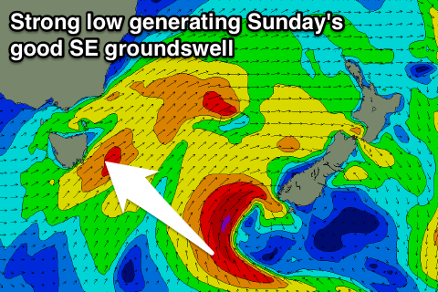
Great Sunday with a good SE groundswell
Eastern Tasmania Forecast by Craig Brokensha (issued Friday 19th September)
Best Days: Saturday at exposed south facing beaches, Sunday, early Monday
Recap
Yesterday was average with poor winds and a weak S'ly swell that developed into the afternoon.
Today the swell was more defined and up to 3ft across south facing breaks with better winds.
This weekend onwards (Sep 20 onwards)
 The weekend is looking better with some good SE swell on the way for Sunday.
Another front pushing up past us this afternoon and evening should keep small levels of S'ly swell hitting exposed breaks with 3ft sets tomorrow, while open beaches are expected to be in the smaller 1-2ft range. Winds should be good and offshore from the W/SW tending W.
Of greater importance is the development of a fetch of SE gales south-west of New Zealand around the western flank of a strong stalling low.
This low will continue to aim a fetch of gale to severe-gale S/SE winds towards us this evening before pushing north and aiming away from our swell window early tomorrow morning.
A moderate sized and strong SE groundswell for Sunday, building through the day and peaking at 3-4ft+ across exposed beaches. Winds look excellent with offshore W'ly tending variable breezes.
Monday morning should still be good with the easing SE swell from 2ft to maybe 3ft at open beaches, back to 1-2ft through the day.
Beyond this there's nothing too major on the cards for next week, so make the most of Sunday's waves! Have a great weekend.

