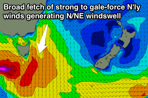
Fun NE windswell peaks later Tuesday and early Wednesday
Eastern Tasmania Forecast by Craig Brokensha (issued Monday 8th September)
Best Days: Tuesday afternoon, Wednesday morning
Recap
Small levels of E'ly swell continued to provide 1-2ft waves across open beaches Saturday before finally fading away Sunday. Today the surf is tiny but a late increase in weak N/NE windswell should have been seen with freshening N/NE winds.
This week (Sep 9 - 12)
The N/NE windswell event expected across the coast tomorrow and Wednesday has been upgraded, with the strong high pressure ridge being squeezed by an approaching front from the west now expected to be much broader and stronger.
A fetch of strong to gale-force N/NE winds will be aimed through our north-east swell window this evening and early tomorrow, kicking up medium levels of N/NE windswell.
 North-east facing beaches will pick up the most size with sets to 3-5ft expected to develop through tomorrow just as winds start swinging offshore. Open beaches will be much smaller though, and protected northern corners smaller again.
Winds will swing from a strong N'ly early to the N/NW during the day and then NW through the afternoon, creating improving conditions and fun peaky waves for the late session.
A quick drop in size is due Wednesday from 2-3ft at north-east facing beaches under favourable but strengthening W/NW winds.
From here on there's nothing major on the cards until later in the weekend with the coast expected to go flat.
Late Sunday's swell looks to be in the form of a S'ly windswell as a deepening frontal system forms into a low off our coast. This may produce better S'ly tending SE swell early next week, but we'll review this Wednesday.

