Large and stormy Friday, cleaner and easing Saturday
Eastern Tasmania Forecast by Craig Brokensha (issued Wednesday 16th July)
Best Days: Saturday
Recap
Yesterday was tiny but a strengthening northerly fetch into the evening produced a fun N/NE windswell this morning to 2-3ft across exposed beaches as winds tended offshore. This swell should of eased slightly into this evening and will be all but gone tomorrow.
This week and weekend (Jul 17 - 20)
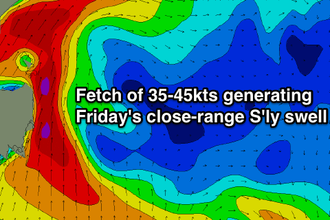
There's been no real change to the easing S'ly swell event on Saturday but, Friday's estimated size has come up significantly.
Firstly I don't think we'll get close to the wave heights forecast by our model, as Wave Watch seems to be overestimating the localised swell generated by a vigorous Tasman Low deepening off our coast.
 This low will form as a result of a cold front pushing in from the west feeding and deepening off a vast pool of cold air in the upper atmosphere.
As this low deepens, a fetch of gale to severe-gale S-S/SE winds are forecast to be generated directly off our coast Thursday evening, generating a large short-range S'ly swell.
Size wise we're probably looking at a more reasonable 3-4ft of S'ly swell at open beaches with bigger 6ft sets at exposed south facing breaks up the North East Coast. Winds will be be poor for exposed spots anyway and strong to gale-force from the S/SW, leaving only protected locations with clean waves which will be small to tiny.
Saturday is still looking like the day to surf, as the low pushes up the East Coast Friday resulting in winds swinging offshore from the W/NW as the swell eases from 3-4ft at south swell magnets and 2ft at open beaches.
The swell will drop steadily through the day and only small 1ft to maybe 2ft leftovers are due into Sunday. Beyond this there's nothing significant on the cards, so make the most of Saturday!

