Plenty of windows of good waves for NE Tas

Eastern Tasmania Forecast by Craig Brokensha (issued Wednesday 11th June)
Best Days: Thursday, Friday, Saturday in protected spots, Monday
Recap
Tiny levels of E/NE swell offered 1-1.5ft waves across the coast yesterday, but today some new E/SE swell filled in, pulsing to 2-3ft and this swell should of peaked this afternoon.
This week and weekend (Jun 11 – 15)
Today's increase in E/SE swell was from a fetch of strong SE winds off the southern tip of New Zealand's South Island. This fetch has since weakened and turned away from us, but open beaches should still offer 2-3ft sets tomorrow morning before easing into the afternoon. Winds should be favourable and from the NW for most of the day, creating clean conditions.
 Friday's swell which was upgraded Monday has now been wound back a touch with the fetch exiting New Zealand's Cook Strait now forecast to be a touch smaller in width and length.
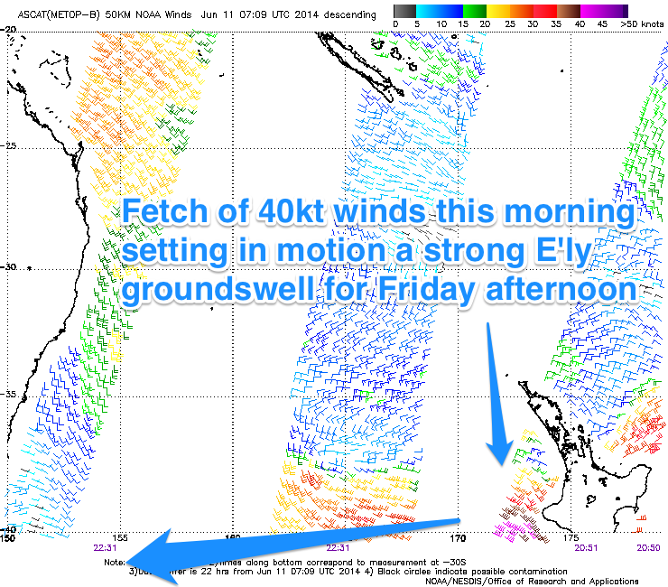
Still in saying this, satellite observations confirm a fetch of 40kt E/SE winds aimed towards the Australian East Coast this morning, with a further strengthening and push more towards the Tassie East Coast expected to have taken place this afternoon.
We can still expect a medium sized increase in strong E'ly groundswell through Friday, reaching an inconsistent 3-5ft later in the day as winds persist from the NW.
A peak is due overnight, with a steady drop in size expected on Saturday from a slightly smaller 3-4ft+.
Winds however don't look as inviting as an early S/SW'ly gives way to a fresh and gusty S/SE change. Therefore protected southern corners will be the best option through Saturday.
This S/SE change will be related to a deepening surface trough/low off our coast and with it a fetch of SE gales are forecast to be generated directly east of us, kicking up a moderate sized SE swell for Sunday. Conditions will be poor through with a fresh to strong S/SE'ly, but look out for a late improvement as winds tend more S/SW.
Monday will be the day again to surf though with the SE swell dropping from 2-3ft or so under offshore W'ly winds.
Longer term there's nothing too major on the cards, so make the most of the coming days of swell and check back here on Friday for an update on the low over the weekend.