Large close-range S'ly swell Sunday with a better easing S/SE swell Monday
Eastern Tasmania Forecast by Craig Brokensha (issued Friday 2nd May)
Best Days: Sunday in protected spots, Monday, Wednesday in protected spots, Thursday
Recap
The coast has been flat the last couple of days, but there should be some more motion through tomorrow and into Sunday.
This weekend (May 3 - 4)
There's still some very large and stormy swell on the way for our coast over the coming weekend.
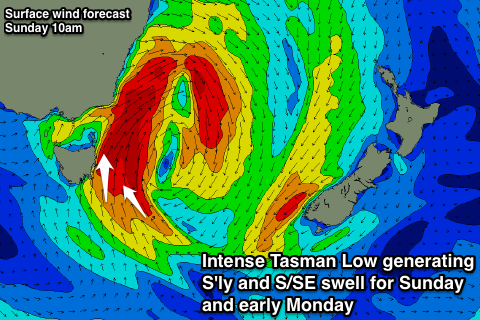
This will be the result of a deep and powerful Tasman Low forming directly off our coast as a deep upper cold pool moves across the south-east of the country.
As this low forms a burst of E/NE gales wrapping in on its eastern flank is due to generate a small increase in E/NE swell across open beaches tomorrow, but this will be quickly replaced by a localised increase in short-range S'ly swell as the low starts to wind up.
The models appear to be overcooking the size expected later tomorrow and also into Sunday due to the windswell contamination in the wave watch data, and we're probably looking at a rapid increase in size to 4-5ft or so across south facing beaches late in the day Saturday and 2-3ft at open beaches.
Winds will be poor in any case with a strengthen S/SW wind.
 Come Sunday though, winds off our coast should reach the gale to severe-gale-force range from the S'th, with an in-feed of S/SE winds to our south-east (pictured right). This is expected to kick up a much larger increase in S'ly swell Sunday, peaking through Sunday afternoon to 4ft at open beaches and 8ft at south facing beaches. Offshore reefs and bommies will likely be much larger but wind affected with associated strong S/SW winds.
Therefore protected locations will offer the best waves over the weekend, but least amount of size under the acute S'ly swell.
Monday onwards (May 5 onwards)
The low is due to move away to the east rapidly Sunday evening resulting in a rapid drop in swell, but the in-feed of S/SE winds through Sunday should produce a fun sized S/SE swell for Monday morning. Exposed locations should offer 3-5ft waves early before easing quickly under strengthening offshore W'ly winds.
As we move into Tuesday another strong cold outbreak is expected to occur across the state, but this system looks better for swell across the region.
This will be due to the system pushing from below us and up past out coast, opening us up to a greater fetch length.
The models are still slightly divergent on the intensity of this system, but south facing locations are likely to see waves in the 4-6ft range late Tuesday and early Wednesday but with poor S/SW winds.
The outlook for the rest of the week is likely to be a steady downwards trend in size with improving winds, but we'll have to review this all again on Monday. In the meantime have a great weekend, and remember to rubber up, it's going to be cold!

