Nothing major until the weekend
Eastern Tasmania Forecast by Craig Brokensha (issued Monday 28th April)
Best Days: Thursday morning, later Saturday in protected locations, Sunday at open beaches
Recap
The NE windswell performed better than expected on Saturday and in line with model forecasts, with north-east swell magnets reaching 3-4ft as winds tending strong offshore.
The swell was gone by Sunday only to be replaced by a weak S'ly swell to 2ft at swell magnets under light offshores.
Today an expected stronger S'ly groundswell pulse has come in at a good 2-3ft at south swell magnets under favourable W'ly tending N'ly winds. The swell should of eased into this afternoon.
This week (Apr 28 – May 2)
Today's fun increase in S'ly groundswell was generated by a strong frontal system pushing across us on Sunday and this system has since raced off towards New Zealand, with a rapid drop in size expected to have taken place this afternoon, leaving nothing tomorrow.
A new N/NE windswell should develop across exposed beaches though with a strengthening northerly ridge ahead of a cold front and evening change. Size wise, only 2ft or so of swell is expected across north-east swell magnets but with poor N'ly winds ahead of that late kick to the NW.
An overnight change should then kick up an increase in S'ly windswell Wednesday, but the models seem to be overcooking this, with only a 3-4ft expected at south swell magnets across the northern half of the coas tand with strong S/SW winds.
Thursday will be the day to surf though as the swell eases out of the S/SE and winds swing offshore from the W/NW. Size wise we should see a dropping 2ft to nearly 3ft of swell so, this will be a good morning to surf, and leave it Friday as there'll be nothing left over.
This weekend onwards (May 3 onwards)
The models have been toying with a strong cold outbreak and deep Tasman Low this weekend off our coast for a few days now.
It looks like they're coming into alignment and what we'll see is one of the first real strong cold bursts of the season.
 A strong node of the Long Wave Trough is expected to shed a deep cold pool off across the south-east of the country, with this feeding the development of a deep and powerful Tasman Low.
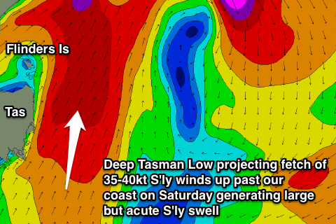
This low is due to form through Saturday, projecting a fetch of strengthen S'ly winds up past our coast that are due to reach the 35-40kt range from the S'th (pictured right) before swinging unfavourably to the SW Saturday afternoon/evening and out of our swell window.
This should generate a rapid increase in short-range S'ly swell but the timing of the peak is still being disputed by the models. GFS has it through Saturday afternoon and in the 4-6ft range, while ECMWF would probably see a peak Sunday morning to a similar size.
Winds through Saturday will be strong to gale-force from the S/SW, while Sunday is looking much better with straighter W'ly winds developing. We'll have to have another look at this system on Wednesday though, so have a check back then for a much clearer idea on the timing of the swell's peak, its size and local winds.

