Great SW swells from Thursday
Java, Bali, Lombok, Sumbawa forecast by Craig Brokensha (issued Tuesday 30th August)
Best Days: Swell magnets tomorrow morning, Bukit reefs from Thursday
This week and next (Aug 31 – Sep 9)
A new funky S'ly swell is building across the coast today, although inconsistent. This swell should reach 5-6ft by dark across exposed breaks before easing steadily from 4-6ft tomorrow morning. With the direction and where this swell was generated, the size will be smaller east of Bali, bigger to the west.
Into Thursday, the first of a series of long-range SW groundswells are due to fill in.
Thursday's will be very inconsistent but strong, generated late last week by a slow moving polar low firing up under South Africa.
This same swell impacted Western Australia today, with 6ft sets hitting the reefs and we should see similar infrequent sets building to 5-6ft through the day.
A secondary pulse of slightly more consistent SW groundswell is due Friday, produced by a piggy-backing frontal system moving up and over the back of the initial low.
 Good 6ft to occasional 8ft sets are due at swell magnets most of the day and early Saturday, easing into the afternoon.
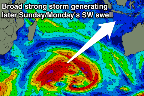
Our larger pulse of SW groundswell is still on track, with a vigorous and broad polar low currently projecting from south-east of South Africa into the central Indian Ocean.
A fetch of severe-gale to storm-force W/SW winds are being generated, setting in motion a large long-period SW groundswell.
Into Saturday an initial smaller long-period pulse from pre-frontal W/NW gales ahead of the main low is expected, offering inconsistent 6ft+ sets at magnets, with the groundswell kicking through Sunday, reaching 8ft later in the day, peaking early Monday morning to 8ft to possibly10ft across exposed breaks.
A drop is then due into the afternoon, and further Tuesday morning.
Later in the day and Wednesday morning a reinforcing long-period S/SW groundswell is due, from a less than favourably aligned by broad and elongated fetch of severe-gale W/NW winds perpendicular to our swell window.
This should keep exposed breaks to the south kicking around 6ft+ before easing into the end of the week.
Longer term another large S/SW groundswell is on the cards for the following weekend, but more on this Thursday.
Conditions will be good most of the period, with weak E/SE-SE trades, light and variable each morning with local land breezes.
16 day Bali Forecast Graph
16 day East Java Forecast Graph
16 day Sumbawa Forecast Graph


Comments
Any notes on South Sumatra Craig? Cheers
Haven't had time the last few weeks sorry Schwaino, will try fit one in Thursday.
No worries Craig. Cheers
Hows that forecast 2 straight weeks of 6-8 foot with 4 days of 10 foot plus 1 day 12-15 foot = fun times
This Sundays swell been on lock now for a few days but models have upgraded now to 12-15 feet at its peak in the arvo. That will be the biggest swell since Muzza one last year and its backed up by two potential 12- 15 feet swells. Signifcantly first twp to both focus on Western Indonesia
You going Mick?
Not so big on latest wam
Yeah Goofy got a 8 day window after Fathers day...haven't booked yet. Agree Cam that wam not looking as impressive as the Muzza swell now.
Your just a bit excited after your injury mick. extra froth on top
Here you go guys!! Indo/Ments forecast update