Mid-period S/SW swell for Saturday, stronger but less consistent swells next week
Java, Bali, Lombok, Sumbawa forecast by Craig Brokensha (issued Thursday 18th August)
Best Days: Friday through Monday morning, later Tuesday through the end of the week
This week and next (Aug 19 - 26)
The swell has been ebbing and pulsing from the S/SW the last few days, holding into this morning, but we should see a drop through tomorrow back to 4-6ft at swell magnets.
Into Saturday our consistent but mid-period S/SW swell is still on track with a relatively weak but north-east projecting mid-latitude front generating a top up back to 6ft to possibly 8ft at magnets.
This swell will ease steadily into Sunday through from the 4-6ft range, further into Monday and bottoming out early Tuesday.
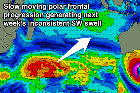
As touched on last update, some better aligned but inconsistent SW groundswell is due into the middle of next week, generated by a slow moving but strong polar frontal progression developing south of South Africa yesterday, and traversing the entire southern Indian Ocean over the coming days, pushing into WA on Sunday evening.
 Two separate pulses of groundswell are the due, the first being least consistent and from the SW, the second a little more consistent and from the S/SW.
The first pulse should start building Tuesday afternoon, reaching 3-5ft across exposed breaks late, and peaking Wednesday in the 6ft+ range. The second S/SW swell looks to come in around a similar size for Thursday, easing back into Friday.
Coming back to the winds, and moderate to fresh E/SE trades today and tomorrow will ease back into Saturday, weak from the S/SE Monday before picking up again with the new swell Wednesday. Each morning though more variable winds are due with local land breezes.
Longer term another moderate sized and inconsistent SW groundswell is due next weekend, with nothing too significant beyond that, but more on this Tuesday.
16 day Bali Forecast Graph
16 day East Java Forecast Graph
16 day Sumbawa Forecast Graph

