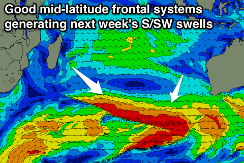
Easing S/SW swell with plenty of surf for next week
Java, Bali, Lombok, Sumbawa forecast by Craig Brokensha (issued Thursday 11th August)
Best Days: Exposed breaks over the coming days besides Sunday when the swell bottoms out
This week and next (Aug 12 - 19)
Easing levels of S/SW swell should currently be seen across exposed breaks, down from 6ft to occasionally 8ft early this morning. This easing trend will continue into tomorrow and Saturday, bottoming out through Sunday as E/SE trades strengthen (light and variable each morning).
Our good run of S/SW groundswell for next week is still on track, although the largest SW pulse for Thursday has been downgraded a touch.
 Currently across the southern Indian Ocean, a flurry of strong mid-latitude frontal activity is taking place, with an initial mid-latitude low firing up towards Margaret River, followed by a drawn out fetch of severe-gale pre-frontal W/NW winds which will then be followed by post-frontal W/SW winds.
Various pulses of S/SW groundswell will be generated off this activity, the first building Monday to 5-6ft+ across swell magnets through the late afternoon, with the largest due to fill in Tuesday, reaching 6ft to possibly 8ft across south swell magnets into the afternoon.
A secondary pulse to a similar size is due Wednesday afternoon, with the less consistent SW swell for Thursday looking to come in around 6ft+. This SW swell will be generated by a more distant, slow moving and weaker polar front projecting from the west of Heard Island.
Both the S/SW and SW energy are due to ease back through Friday, with a slight reinforcing S/SW pulse for Saturday keeping 6ft sets hitting magnets.
Longer term moderate pulses of S/SW swell are due to continue into the week starting the 22nd, with a larger SW pulse still likely maybe late week, but more on this Tuesday.
16 day Bali Forecast Graph
16 day East Java Forecast Graph
16 day Sumbawa Forecast Graph

