Bali: Plenty of swell, largest next Tuesday
Java, Bali, Lombok, Sumbawa forecast by Craig Brokensha (issued Tue 29th Jul)
Best Days: Every day besides Monday morning
This week onwards (Jul 30 onwards)
After a large and good pulse of SW groundswell yesterday wave heights have dropped back a touch into this morning, but we should see a late kick in new S/SW groundswell this evening, peaking through tomorrow.
This swell was generated on the tail of the cold front responsible for yesterday's swell and should boost exposed breaks around Bali back to 8ft+. Protected spots will be smaller but cleanest with fresh to strong E/SE trades through tomorrow.
A further drop in size is due through Thursday as the trades relax just a touch, opening up a small possibility of variable winds through the morning.
Into Friday another long-range S/SW groundswell is due across the coast, generated by a flurry of polar frontal activity pushing up and into WA the last couple of days. Inconsistent 6ft to occasionally 8ft sets are due across exposed breaks from mid-morning before dipping away from just over 6ft Saturday morning.
Sunday should see a new similar sized pulse of acute S'ly groundswell generated late in our swell window today, to the south-west of WA, and this won't perform as well on the Bukit and come in better across East Java. Sumbawa won't see too much size at all due to the shadowing of the Western Australian coast. Size should be similar but less consistent to Friday's pulse but fresh to strong E/SE trades will limit options.
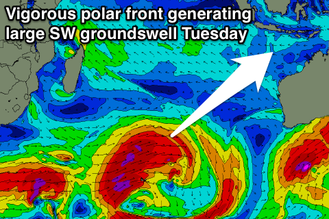
 As touched on over the past week, the longer term outlook is exciting with a large and powerful SW groundswell lining up for the first week of August. This will be produced through the Southern Indian Ocean by a very broad and strong couple of cold fronts. An initial fetch of severe-gale SW winds south-east of South Africa will set up an active sea state for a much broader and stronger frontal system to generate an additional fetch of severe-gale W/SW winds over.
This will generate a large and powerful SW groundswell, arriving later Monday and building towards a peak through Tuesday to 10ft+ across exposed breaks. The trades are expected to keep blowing for this swell before easing off a touch through the week along with the swell.
16 day Bali Forecast Graph
16 day East Java Forecast Graph
16 day Sumbawa Forecast Graph


Comments
hows it looking out beyond this next big swell? get on this one or have I got time up my sleeve....?
frothin for a little hit n run in the next week or two....
Nothing as big lining up, so I'd hit it!
Seems like a bit of a downgrade on that Tuesday swell- which way to head from Bali... hmmm west or east?
Yeah, will peg it back a touch more likely 8-10ft or so. Strong E/SE trades look to make the decision easy.
Is it just me, or has this indo season been seriously pumping? I don't normally watch it this closely, but from memory there's usually a month or two that have back to back 8ft swells, with lots of 4-6 stuff in between. I don't think a week has gone by this year without a double overhead + swell, since May
It's been a banner season Shoredump, no doubt about it. Early season pumped and the pattern has continued. Hope it stays that way too, I'm off to the Ments in September.
Go Stu
I'm with you Stu, I'm off to Simeulue Island at the end of August/early September with a couple of mate on my first lads trip since the first offspring arrived 6 years ago. The season so far has been pretty epic by all accounts so fingers crossed, it keeps up!?