Bali: Three large swells within a week
Java, Bali, Lombok, Sumbawa forecast by Craig Brokensha (issued Thu 19th Jun)
Best Days: Every day over the coming period
This week and weekend (Jun 19 - 22)
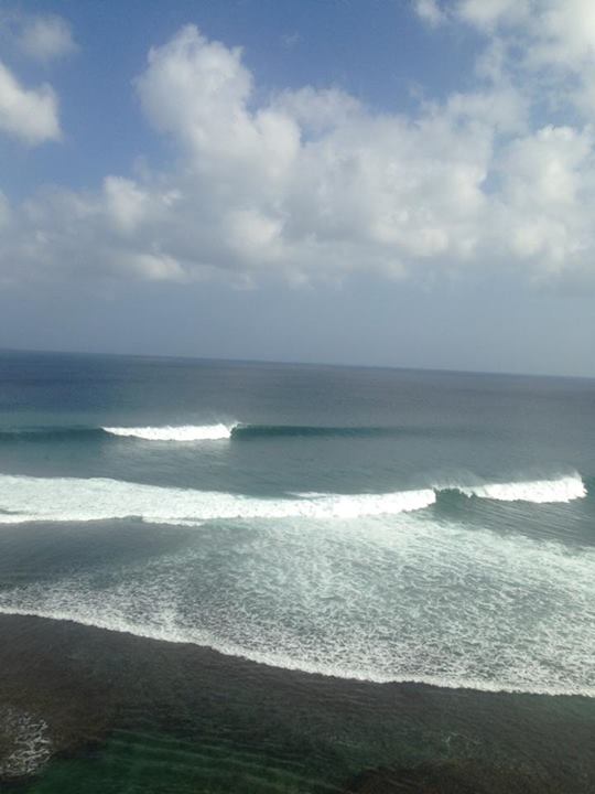
 A good pulse of SW groundswell filled in yesterday across the region, but today the much larger and stronger SW groundswell due across Indonesia is starting to push with photos appearing of Outside Corner breaking on the Bukit (photo by AB).
This swell should continue to pulse to a strong 10ft+ by dark at exposed locations around Bali with a peak overnight and drop from a similar size early tomorrow. Smaller waves will seen over towards Sumbawa and the further east you travel.
The swell should ease steadily through the day tomorrow and further Saturday, with a slight kick in size seen through Sunday afternoon as a reinforcing S/SW groundswell fills in.
This swell should simply boost exposed locations back to the 6ft range as today's fresh E/SE trades ease and become variable.
Next Monday onwards (Jun 23 onwards)
The first of two large SW groundswells due next week should arrive through Monday afternoon and peak Tuesday. This swell is being generated by a great looking polar front that started it's life north-west of Heard Island and is projecting north-eastwards towards us while generating winds in the 35-40kt+ range.
The north-east projection will help generate a large and consistent SW groundswell that is expected to build to 8ft at exposed spots around Bali later Monday and peak Tuesday to 8ft to occasionally 10ft.
Winds look to be mainly light and variable opening up plenty of options across the region.
The swell should drop away through Wednesday and bottom out on Thursday to 3-5ft at exposed breaks.
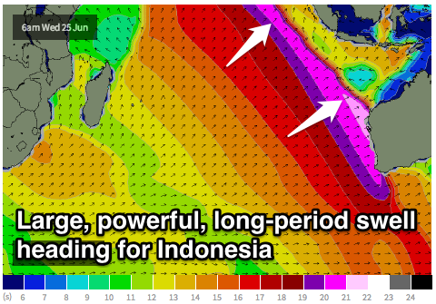
 The second pulse of large SW groundswell will have more west in it and also be a lot less consistent, generated in our far swell window south and east of South Africa.
The frontal progression generating this swell will be a monster, with a broad initial fetch of 35-45kt gales expected to produce an active sea state for an additional fetch of 35-50kt winds to move over, setting in motion a large, long-period SW groundswell.
The forerunners of this swell should arrive through Thursday morning in the 22s range, but the bulk of the swell is due Friday with inconsistent but strong 8-10ft+ waves expected across exposed breaks.
Light E'ly trades will create clean conditions, with a more variable breeze likely during the morning.
The frontal progression producing this swell will continue on its way in a weakened form through the Southern Indian Ocean a couple of days after it's reached its peak intensity and this will help slow the easing trend through next weekend.
Beyond this large swell there's nothing too major on the cards with much smaller surf due the following week so make the most of the coming period of waves!
16 day Bali Forecast Graph
16 day East Java Forecast Graph
16 day Sumbawa Forecast Graph


Comments
Thanks Craig I dropped my son off at the airport on Tuesday and he is in West Sumbawa now and will be having a ball with this forecast. I am off to Bali on the 30th. Is it too far out for any info' after that?
At this stage looking at a quieter period, especially compared to the coming week and a bit. Keep an eyeont the last paragraphs in the coming forecasts for ongoing updates.
Thats a pumping week........Good to see Sally Fitz on instagram bail the State of Origin and go chase these swells in Bali
Memla, the long range has it going flat just when you arrive....bad luck..... but sure it will bounce again pretty soon though
will there still be swell around through the 27th to the 29th, staying on bingin
Holla, as Don pointed out, and as discussed with much froth above, a monster swell is arriving through that period. Size has been upgraded as well since this update with 10-12ft+ surf now likely around exposed spots in Bali.
Holla, if you're talking about June, then ummmmmmm, YES there will be swell and you may wish to think about getting a step up for it!!!! ;)
Seriously 12-15ft on the 27th?? meant to head into G-land that day..... Not sure what to think now. Should be worth seeing not sure about surfing!
Yeah, it's going to be very big on the outside sarge. Speedies should be in the 6-8ft range, be smaller options further inisde as well.
gotta be in it to win it i guess..... the whole next 7 to 10 days looks epic, yeah?
Yes it does!!!
Craig et al any real thoughts on why Indo has been pumpin with back to back swell over the last 3-4 weeks? I mean it hasn't stopped below 6ft, with some monster days up in thr 8-10ft and this week looks bigger again!!!!
Basically the westerly storm track finally started to kick into gear and there have been numerous nodes of the Long Wave Trough passing through the Southern Indian Ocean from South Africa all the way over the Western Australia.
All this activity is starting to focus more towards Australia though, hence the active period for the Southern States over the next week and a bit.
Don't forget that there has been an abundance of warmer water off the Eastern Coast of Africa out as far as RI , and now that the Southern Storm track has kicked in ( whether through the SAM's influence in more nth / sth aligned upper jetstreams or just lower central presures in nodal LWT activity ) . The two have seen systems really ramp up or hold strength even after being bunched up after passing Sth of Africa . Alot of the time after a system moves into the Indian it will expand and lose intencity . If this warmer water isn't present then the systems tend to weaken a little on entering the Indian area of the Southern Ocean , then bomb further east after a secondary interaction , be it from Uppers or sea surface / currents , later or not at all ... Generally surface instability is invigorated by poleward troughs or cutoff lows moving back down poleward . But in this last few weeks case , the fronts have created the instability over warmer sea surface conditions . Leading to systems bombing to aim more Equatorial in movement ( push up and expand whilst maintaining central intencity or even bombing ) like the last one . ?
Yeah, will have to look into the SAM tomorrow and see if it's had any major influence.
Remember the SAM will most likely change up to 2 weeks or 10 days prior to a visible event .
Southey, just looking at the Southern Annular Mode (link) I can't see how this can be helpful especially when the indice is an indication of the entire westerly storm belt around the Southern Hemisphere not for just one region.
Say the westerlies are surpressed over near South America, but higher in latitude over Australia, does that then give an indix of around 0?
If the index where basin/regionally based I think you could get an idea, but going on the month of June, which has been very active, the index has been generally positive and quite strong at times.
This correlates with the westerlies contracting to Antarctica (but we've seen the opposite happen) and higher pressures over southern Australia (which has occured).
The better index for me is the upper atmospheric height anomalies as these show a better picture of what's been and also what's to come.
Been an amazing run of waves over there. How long do you think this slow period will last? Are there any swells lined up?
Well another large swell is lining up for late next week, check back for the new update tomorrow.