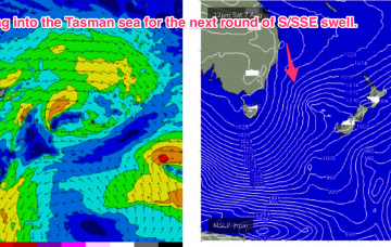
This is another impressively large and complex system, with a double headed low centre forming in the deep southern ocean around 60S and a more proximate cold front fetch expected to push NE to be adjacent to Tasmania through Monday morning.
Primary tabs
/reports/forecaster-notes/sydney-hunter-illawarra/2021/08/13/flukey-s-swells-continue-weekend-solid-s
freeride76
Friday, 13 August 2021

/reports/forecaster-notes/sydney-hunter-illawarra/2021/08/11/small-flukey-surf-ahead-another-strong-s
freeride76
Wednesday, 11 August 2021
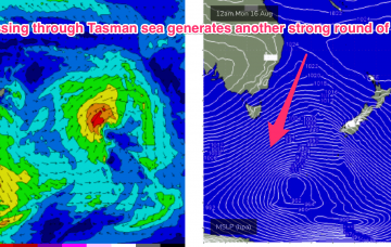
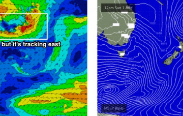
The very active Southern Ocean pattern reaches a crescendo late Sun into Mon with an intense, complex polar low which becomes slow moving as it enters the Tasman sea swell window.
/reports/forecaster-notes/sydney-hunter-illawarra/2021/08/09/few-days-smaller-surf-and-nly-winds-get
freeride76
Monday, 9 August 2021
Energy radiating from this source fetch is expected to see a slow tail off in wave heights through tomorrow, with some rideable leftovers Wed, but you will have to deal with freshening N’ly winds.
/reports/forecaster-notes/sydney-hunter-illawarra/2021/08/06/more-ssse-swell-the-way-some-troublesome
freeride76
Friday, 6 August 2021
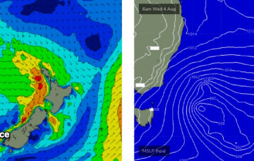
Our “long tail” is still on the menu to start next week. With the small but intense low becoming slow moving as it drifts NE up towards the Northern peninsula of the North Island, crossing it overnight Sun.
/reports/forecaster-notes/sydney-hunter-illawarra/2021/08/04/plenty-s-swell-the-way-long-tail
freeride76
Wednesday, 4 August 2021
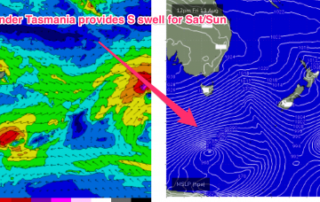
A small trough Sat east of Tasmania separated from the polar flow forms a compact low that super-charges another SW fetch of severe gales that tracks aggressively NE into the central Tasman overnight Sat into Sun.

/reports/forecaster-notes/sydney-hunter-illawarra/2021/08/02/solid-spike-winter-s-swell-thursfri
freeride76
Monday, 2 August 2021
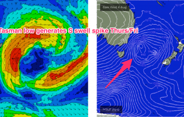
Thursday is a much better bet for a more solid spike in S swell. A series of severe gale strength SW fetches slingshot around the eastern flank of the low, tracking NE into the Tasman and generating several S swell pulses.
/reports/forecaster-notes/sydney-hunter-illawarra/2021/07/30/small-bit-then-return-strong-sly-energy
thermalben
Friday, 30 July 2021
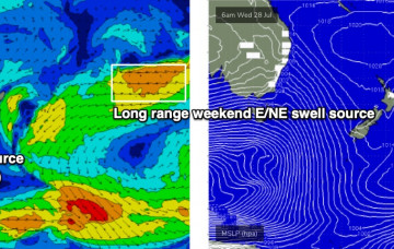
There’s not much surf expected this weekend. But, we have a few long term sources shaping up nicely.
/reports/forecaster-notes/sydney-hunter-illawarra/2021/07/28/only-one-small-swell-work-around
thermalben
Wednesday, 28 July 2021
A vigorous front will push east of Bass Strait tonight, and strong to gale force W/SW winds in its wake will generate a flukey south swell for Southern NSW.
/reports/forecaster-notes/sydney-hunter-illawarra/2021/07/26/jittery-the-periphery-small-flukey-south
thermalben
Monday, 26 July 2021
Look, there’s really not much to get excited about this week. Only one swell to work around.
/reports/forecaster-notes/sydney-hunter-illawarra/2021/07/23/patchy-outlook-flukey-south-swells-best
thermalben
Friday, 23 July 2021
The weekend's strong frontal progression will be detached from polar latitudes, so we’re looking at another spell of small conditions interspersed with flukey south swells.
