Largest swell of the season possible next week
The Indian Ocean is starting to turn all shades of red and purple as a flurry of strong and northward projecting storms fire up.
Not soon after one of the best weeks of the season last week, with large back to back south-west groundswells, we're set to see a very large and possibly the biggest swell of the Indo season hitting next Tuesday.
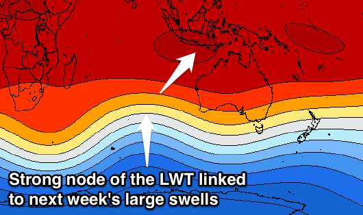
 This will be related to back to back polar frontal systems firing up under the influence of a strong node of the Long Wave Trough in the southern Indian Ocean.
An initial frontal system has already aimed a fetch of severe-gale south-west winds towards Indonesia, with this storm expected to weaken slightly while continuing to project towards the region.
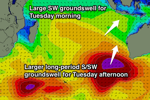
A large south-west groundswell is expected, kicking later Monday and peaking Tuesday morning to 8-10ft at exposed breaks, but this will be around the same time a much larger and more powerful south-southwest groundswell arrives.
The source of this large swell will be a secondary much stronger polar front projecting a broad and elongated fetch of severe-gale to sub-storm-force on top of the active sea state produce by the first storm, resulting in rapid wave growth.
 Larger 10-12ft sets are due across exposed south facing breaks when this swell peaks through the middle of the day/afternoon with moderate east-southeast trades. The Bukit reefs will be a bit smaller with the more southerly direction but still large and only for experienced surfers.
The easing trend will be softened through Wednesday owing to a large reinforcing south-southwest groundswell filling in, generated on the backside of the flurry of frontal activity due over the coming days.
Easing surf from 10ft+ is expected Wednesday, further into the end of the week.
16 day Bali Forecast Graph
16 day East Java Forecast Graph
16 day Sumbawa Forecast Graph


Comments
Yeah craig impressive summary