Easterly winds set in with smaller swells

Victorian Forecast by Craig Brokensha (issued Friday May 3rd)
Best Days: Selected spots east of Melbourne tomorrow morning and Monday morning, Tuesday exposed beaches and early Wednesday
Features of the Forecast (tl;dr)
- Easing S/SW swell all weekend with moderate E/SE-E winds ahead of gusty SE breezes
- Small SE windswell in the mix all weekend
- Inconsistent W/SW groundswell arriving later Sunday, peaking Monday morning, with a better pulse for the PM and Tue AM, easing
- Moderate E/SE-E tending fresh SE winds Mon, E/NE tending N/NE Tue, NE into the PM
- Easing swell Wed with N/NE winds ahead of a shallow S/SW change
- Small new S/SW swell Thu with S/SE winds
Recap
Background levels of S/SW swell have persisted around the 3ft range on the Surf Coast both yesterday and this morning with waves around 4ft to the east. Conditions have been OK to the east through the mornings, best today.
This weekend and next week (Apr 4 - 10)
The current S/SW swell energy is due to ease into the weekend, with the exposed beaches to the east fairing best.
Tomorrow should still be 2-3ft on the Surf Coast magnets, but full, slow and easing through the day with 3-4ft sets to the east, smaller into Sunday.
A moderate E/SE-E breeze will favour selected spots both tomorrow and Sunday mornings ahead of sea breezes.
Similar winds are due into Monday morning along with a mix of inconsistent W/SW groundswells, with the first due to build later Sunday.
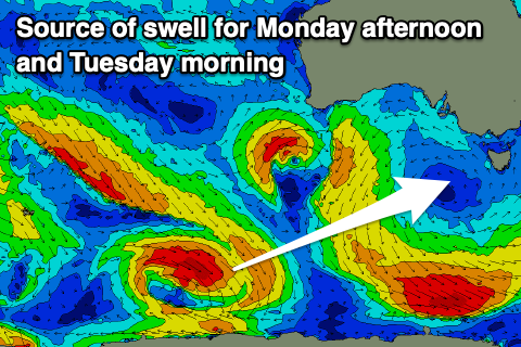
As touched on in Wednesday’s notes, a very distant but strong Southern Ocean frontal progression through the Indian Ocean has generated an inconsistent W/SW groundswell for later Sunday and Monday to 2ft to occasionally 3ft on the Surf Coast and 4ft+ to the east.
A better pulse of reinforcing W/SW groundswell is due to fill in through the day, generated by a strong low that formed east of the Heard Island region Wednesday evening.
This should produce a more convincing 2-3ft of swell for the Surf Coast into the afternoon, 4-5ft on the sets to the east, easing back Tuesday from a similar size.
Winds are due to be best Tuesday with an E/NE tending N/NE breeze, tending lighter NE through the afternoon as the swell slowly eases. This is the pick of the coming days.
Wednesday will be clean again with a bit more north in the wind, but smaller, fading surf. The exposed beaches will be the pick early before a trough brings a shallow S/SW change later morning.
Into Thursday, a small lift in S/SW swell is due, generated by a late forming frontal system south of country. Otherwise, we’ve got more dominant high pressure on the cards with easterly winds along with background S/SW swell energy. More on this Monday, have a great weekend!
Comments
So incredibly grim. Not sure what we've done to deserve this brutal easterly wind flow during prime season. Can we find someone to blame please?
You. Whoever smelt it, dealt it.
Someone please be happy for us 'Ninch' surfers who suffer through Westerlies.
There's always another side to that coin (or of Melbs!). I'm clearing the schedule personally ;)
+1 these are the forecasts i wait for, opens up many options on the far west coast beachies too.