Good swells with great winds inbound

South Australian Forecast by Craig Brokensha (issued Monday May 9th)
Best Days: South Coast Wednesday, Thursday, Friday, Saturday and Sunday, Mid Coast Thursday afternoon and Friday (for the keen)
Features of the Forecast (tl;dr)
- Easing S'ly swell tomorrow with fresh S/SW winds (possibly light W/NW early around Victor)
- Moderate sized, inconsistent SW groundswell Wed AM, easing with NW tending N/NW winds
- Large W/SW groundswell building Thu, strongest later, easing slowly Fri (biggest South Coast Fri)
- N/NE-NE tending variable winds Thu, moderate N/NE winds Fri
- Smaller Sat with strengthening N/NE tending N/NW winds
- Moderate sized, mid-period W/SW swell building Sun, holding Mon with stronger NW winds Sun, W/NW tending W/SW Mon
Recap
Saturday saw choppy, semi-stormy waves across the Mid Coast in the 3-4ft range while the South Coast built in size under cross-offshore winds.
The cold, broad low linked to all the wind and weather started to move east through yesterday bringing onshore winds and some larger, S’ly swell across the South Coast while the Mid Coast improved under cross-shore winds along with easing 3ft sets. The quality wasn’t quite there though with lots of windswell in the mix.
Today we’ve got our window of favourable conditions down South with S’ly swell to 4-5ft, while the Mid Coast is also cleaner but lumpy and mixed to 1-2ft.
This week and weekend (Jun 10 - 15)
This morning’s W/NW breeze is just a temporary reprieve from the onshore flow on the backside of the low that’s now moving further east and into the Tasman Sea.
With this, a return to freshening S/SW winds is due this afternoon, persisting tomorrow. There’s a chance for light, local W/NW winds around Victor early tomorrow but with weaker, easing levels of S’ly swell.
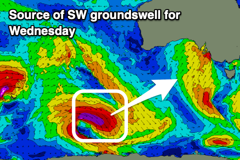
Our better SW groundswell for Wednesday is on track, with a strong polar low forming over the weekend to the east of the Heard Island region, generating a great fetch of severe-gale to storm-force W/NW winds aimed towards the polar shelf.
The swell may be seen on dark tomorrow but should peak Wednesday morning to a good 4ft across Middleton, tiny inside the gulf.
Local winds look more reliable and NW tending N/NW through Wednesday, holding into the afternoon.
Now, our second pulse of stronger W/SW groundswell for later week is also on track, with a strong mid-latitude low forming in our far western swell window over the weekend. It’s north in latitude and best positioned for the Mid Coast, with a great fetch of severe-gale to storm-force W/SW winds projected through our western swell window.
The low is now weakening on approach to Western Australia, with the groundswell due to arrive Thursday, building strongly into the afternoon and then easing slowly Friday.
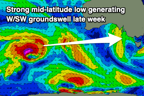
The remnants of the low may reform south of Western Australia tomorrow evening, providing an additional boost in size, but we’re expected to see building surf to 3ft by later Thursday on the Mid Coast, easing from a similar size Friday with the South Coast struggling a little for size and consistency thanks to the blocking effects of Kangaroo Island.
Middleton should offer 4ft+ waves Friday, easing through the day.
Local winds on Thursday look great for the afternoon on the Mid Coast with moderate N/NE tending variable breezes, with Friday seeing moderate N/NE winds persisting most of the day.
Come the weekend, easing levels of swell are due with strengthening N/NE tending N/NW winds.
Into Sunday, an inconsistent, long-range SW groundswell is due from the Heard Island region, with a distant fetch of strong to gale-force winds expected to generate some slow, small to moderate sized sets into the afternoon and Monday morning.
The Mid Coast looks to see 1-2ft waves from this source with Middleton coming in at a better 3ft+ under strengthening NW winds Sunday, possibly shifting W/SW through Monday.
Longer term the outlook remains active with a constant progression of swell generating systems due to move in from under Western Australia. More on this Wednesday.
Comments
Winter is here.