Great weekend, also good next week

South Australian Forecast by Craig Brokensha (issued Friday 24th June)
Best Days: Every day South Coast, Mid Coast Saturday and Monday keen surfers
Recap
Poor stormy 2ft waves across the Mid Coast most of yesterday, with the South Coast being cleaner but small in the morning, better later in the day with a new mix of swells.
Today a stormy swell was coming in at 3ft+ on the Mid, with plenty of size down South but average conditions under a strong W'ly wind early, but this has since shifted strong SW.
This weekend (Jun 25 - 26)
The strong front pushing into the state today is generating an additional short-range SW swell for this afternoon, with lots of size holding into tomorrow, easing later in the day and much more noticeably into Sunday.
Conditions will be great as the front moves off quickly to the west resulting in light N/NW wind, increasing through the day. Middleton should see 4-5ft sets, with larger waves at Waits and Parsons, easing back from 3ft Sunday morning.
The Mid should ease from 2-3ft, with an early variable wind tending N'ly through the day but without too much strength.
Winds Sunday will be fresher from the N'th tending NW through the afternoon so the Mid will be bumpy and dropping from 1-2ft.
Next week onwards (Jun 27 onwards)
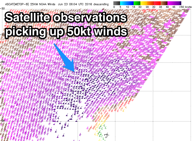 Our large W/SW groundswell for Monday is still on track with satellite observations confirming a fetch of slow moving storm-force SW winds from the Heard Island region since Wednesday night.
This low will continue to push towards us while weakening slowly over the coming days, with a large powerful long-period W/SW groundswell left in its wake.
The swell will arrive during the early hours of Monday morning, peaking through the day to a large powerful 5-6ft+ across Middleton and 8-10ft at Waits and Parsons, with 8ft sets at offshore reefs around town. The Mid is expected to see strong 3ft to occasionally 4ft sets on the favourable parts of the tide.
Winds will be best for the South Coast with an offshore NW'ly, swinging more W'ly through the day as a weak change moves through.
Tuesday then looks excellent on the backside of the swell with NW winds persisting all day.
A reinforcing S/SW groundswell is due across the South Coast later in the day Tuesday, easing Wednesday. This will be produced by a tight but intense mid-latitude low firing up on the tail of the main weakening low. A fetch of severe-gale to storm-force W/SW winds will be generated, keeping 3-4ft waves hitting Middleton Wednesday morning and 5ft sets at Waits and Parsons, easing through the day under strengthening N/NW winds. We'll have another look at this Monday though. Have a great weekend!
Comments
Nice lines at Victor this afternoon.